
Saturday:
Two days after climbing the Guillaumet, I met Franz (Rolo’s name for Francesco, the Italian guide we met) in the supermercado. We talked about our future plans and his idea was the same as Rolo’s: to climb Cerro Solo on the coming Sunday. His plan was to hike to a bivy past the Tyrolean above Campamento Agostini on Saturday night and leave there at 2 a.m. I mentioned that we were thinking of doing it as a day climb from town and he said that is fine but that we should leave at 11 p.m. Ouch! That had us searching for other options. I pinged Dylan and he suggested Mojón Rojo. I conferred with Rolo too. He liked that peak and said it has great views. When I asked what the weather was like on Saturday — not Sunday —, Rolo knew what I was thinking: of doing Mojón Rojo on Saturday and Cerro Solo on Sunday. He advised against it, thinking that the winds would beat us up too much on Saturday.

 |
| Our route is the one marked "1". |

The next morning the Samurai and I got a later start than planned. Samurais are not ninjas, they can’t see in the dark, and taking a headlamp violated the noble tenet of laziness, which is part of the alpine samurai way (“light and fast” as they call it - but I know better). So, at 5:20, we left the apartment and headed north. It was so windy, that I had to put on my shell to get the trailhead. Once there, the ascent had me generating enough heat to shed it. We hiked the Fitz Roy trail to Campamento Poincenot, which was a regular tent city! I was shocked how many tents and people were there. It makes sense, though, as it is an ideal staging ground for a number of great hikes. It was here that we made our first route finding mistake. We headed up the south side of the Rio Blanco…
We followed a great trail until it ended at a peninsula. Fast, deep water cut progress on three sides. We searched in vain for a crossing and then wrestled with the decision to wade the river, but that looked cold and dangerous, as it was a bit deep. It might have approached waist deep and we weren’t sure we’d be able to hold our position. Still, we were about to try it until I realized, duh, we could just hike back to the regular trail, cross the river at the bridge and then head up the correct side.

On our way down to do just this, Derek found a possible route across the river. It involved a leap so far and so daring that I obviously went first, based on my characteristic leaping ability. On the Guillaumet my leaping had landed me in the menacing maw of the bergschrund. Now it put me in the raging rapids of the Rio Blanco… For my leaping characteristic is not one of prowess, but of failure. There was no point in Derek leaping first only for me to be swept downstream. I readied myself and didn’t deliberate, for thinking too much about such a leap would just convince me I couldn’t make it. I launched across the gap, confident I’d live, feeling assured I’d grasp the edge of the smooth white boulder. Indeed I did, but my feet, clad in the friction-free soles of my Neutron G’s, slipped off and I dangled in the torrent. I held fast, though, and pulled myself out. Crisis averted. Even Derek’s foot slipped off a little on his leap, but it lacked my drama.
 |
| Pure leaping talent... |
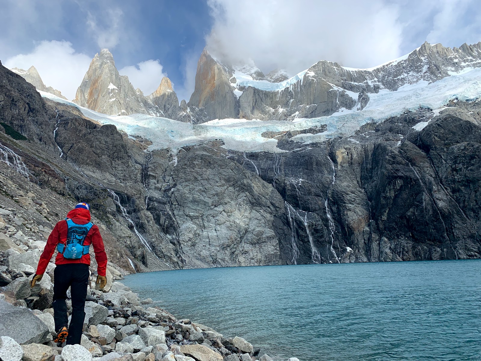 |
| Worth just to get to here. Amazing stuff. The spires we can see, starting with the little on on the left is De l'S, St Exupery, Rafael, and Poincenot. Fitz Roy remains obscured here, |
We traversed around the lake, mostly staying right next to the shore. This was a bit tedious, as the going was upon boulders, large and small, and a long ways. Near a prominent stream emptying into the lake, Derek found the first cairn, indicating it was time to head upwards. I led the way, following the cairns until I lost the track and any sight of another cairn. I led us upwards, off route, for 500 more feet before we realized my error. Derek took over the lead and led us back down. This was smart. I might have been inclined to try and cross the stream higher up, but there was verglas everywhere and this would have been exceedingly dangerous.
 |
| The higher we got above it, the cooler the color of the lake. Derek is requesting some "pre pee" (aka water). |
We continued above on the well-marked route. As we approached the glacier above, the angle eased and we started scrambling up smooth slabs, many of which were covered in verglas and gave us some pause, until we found we could wind our way past the icy sections. Once at the glacier, we donned our Microspikes and got out our poles and axes — one each.
 |
| Starting up the glacier, high above the lake |
 |
| Derek enjoying being in such an outrageous place. |
We climbed up mostly talus to some steep scrambling with many loose rocks. It was not overly dangerous with care. The crux route finding was probably finding a solid traverse under the two big towers low on the ridge. Once around these we encountered some very exposed sections on the ridge, as the other side of Mojón Rojo plunges a couple thousand feet. The view of the Fitz Roy massif, especially Poincenot, were awe inspiring and intimidating. It was incredible to see such giants up close.
The crux climbing, besides the final block, was climbing the steep step that is prominent on the ridge. We got through it with a few 5th class moves.
 |
| De L'S, St Exupery, Rafael, and the immense Poincenot |
The final summit tower is rated (4+ or 5.7). It’s only 25 feet high, but in the cold and the full force of the wind, this had our full attention. Derek went up one way and I another. I spiraled around the pinnacle and part of my ascent was out of the wind. Derek then made a traverse of the summit pinnacle, descending my route. We made the top after 7h35m from our apartment and we immediately started down, as conditions were not enjoyable. Things went smoothly on the descent and we took a short lunch break back where we had stashed the Microspikes, poles, and axes.
 |
| Climbing the steep step below the summit, as the weather moves in. |
We reversed back to the cave and then down the trail to the stream crossing. Here we saw the first people since leaving the Fitz Roy Trail. Two climbers, a male and a female, with rather large packs had just crossing the stream and were heading upwards. We didn’t pass close enough to ask what their objective was. Back down at the lake, as we traversed back to the east, we first ran into another couple. They were planning to do our route the next day. Cool. A bit further on, a 3-person team was coming along the lake. Amazingly, it was Franz and his two clients — the three people with which we had shared the summit of the Guillaumet. It was such a nice coincidence. They are all so friendly. Franz asked for the beta on the route and I spewed all I could remember.
 |
| The summit tower. I started on the right skyline and crossed to this face, just blow the summit. |
 |
| On the very summit. I'm lying on it and Derek is hanging from the top. |
The rest of the way back was easy, but long. We hit the trailhead in Chaltén in just under 12 hours, but it was another 12 minutes back to the apartment. With our two route-finding errors, we’d managed to log over 22 miles and 8500 vertical feet. Sheri immediately fed us. It’s so nice having her here as our basecamp manager and meteorologist.
 |
| Derek descending from the summit |
No comments:
Post a Comment