Tom and I were hiking toward Ruper at 6 a.m. this morning. It didn't feel that cold out and I was hot by the time I had scrambled up the Lower Ramp to the base of the route. That didn't last... My hands were numb after following the first two pitches (strung as one by Tom). I led the traverse and across the Upper Ramp to the base of the 4th pitch, which Tom led. I then led the last two pitches on one and endured some defrost pain at the top. Runout with numb hands does tend to focus the concentration. Pitching it out and the cold weather caused us to be a bit slow, taking 2h25m for the roundtrip back to the car. No big deal for me, but Tom missed his morning stand-up meeting. We should have been able to do that under 2 hours. I've simul-climbed the roundtrip with Buzz in under an hour.
Friday, May 11, 2012
Wednesday, May 09, 2012
Opened the Morning Eldo Season Today!

Tom and I met at 6:30 a.m. and did the Bulge (4 pitches, 5.9). We pitched it out with Tom taking the odd pitches. Numb fingers for the first two pitches, then really nice. That took about an hour and then we soloed Breezy (2 pitches, 5.5) and were back at the car at 7:55 a.m.
Monday, May 07, 2012
Zion Trip Summary
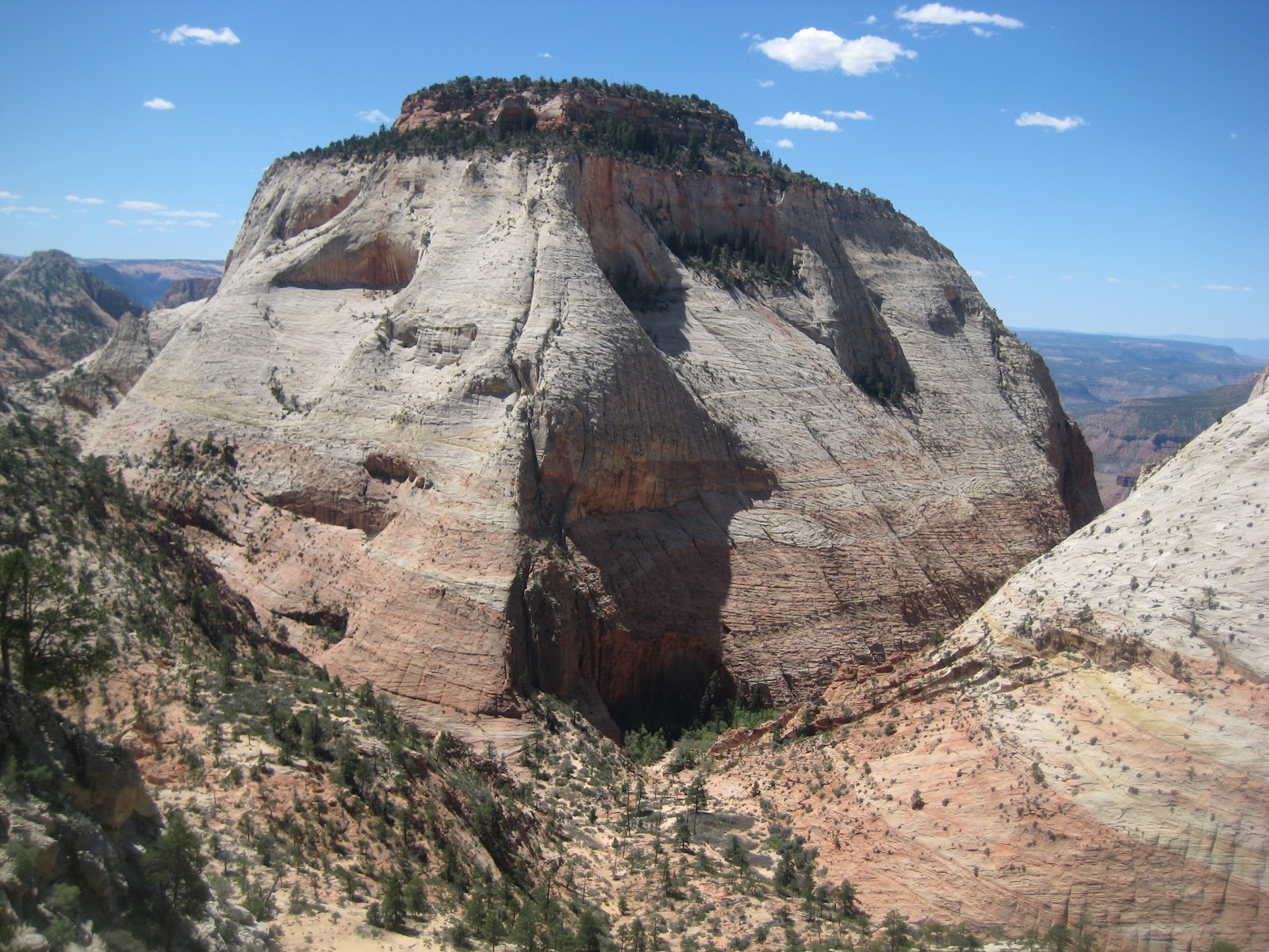 |
| The impressive East Temple |
For the last few years I've gone to Zion for the last week in April. I just love this place and am not bored in the slightest. I plan to be back next year as well. Here's a summary from the 2012 Trip:
Zion Day 1: The Organ
Zion Day 2: Deer Trap Mountain and Hidden Canyon
Zion Day 3: Johnson Mountain
Zion Day 4: Smashmouth
Zion Day 5: The Watchman
Zion Day 6: Confluence Area Cragging
Zion Day 7: Observation Point and Jenny Peak
Zion Day 8: Sheer Lunacy
Zion Day 9: Angel's Landing Run
I did a total of 103 miles (49 running, 13 biking, 41 hiking) with 25,000 feet of climbing, roped up for 28 pitches on 11 different routes, made 6 summits (The Organ, Deer Trap Mountain, Johnson Mountain, the Watchman, Jenny Peak, Angel's Landing), and descended two canyons.
Zion Day 9: Angel's Landing

Map
I love the trail up Angel's Landing. I think it is one of the greatest short trails I've ever done. In only 2.5 miles it goes along a babbling Virgin river, switchbacks up a sandstone wall, goes through a steep, cool canyon, up the famous Walter's Wiggles, and finishes with an extremely exposed via ferrata to an outstanding summit in the most awe-inspiring sandstone canyon in the world. I've done it many times and run it for time 3 or 4 times before. Each time my goal is to break 30 minutes. Last year I made it with just two seconds to spare. I warmed up by running the 2.5 miles to the Confluence bus-stop again and then got off at the Lodge so that I could run another half mile over to the start.
I went hard, but paced myself. Perhaps I paced myself too comfortably, as I didn't really suffer until the last five minutes when I feared I might not break the half-hour mark. I touched the top of the summit boulder in 29:37. I didn't linger at all, since I needed to get in 12 miles of running and drive 11 hours home today. I descending quickly, returning to the bridge just 51 minutes after leaving it. I got a quick drink and then ran back to the campground, finishing up with 13.5 miles and nearly 2000 vertical feet.
And that was it. That was my week. We bid goodbye to Opie and Loobster and I drove off for Grand Junction and then I took it solo back to my house in Superior. It was a very productive and enjoyable week, mostly because of my great companions. I'm still not done with Zion. There is lots more to do there. If I was a better climber there would be even more to do...
Zion Day 8: Sheer Lunacy
Photos Map
Opie and I had absolutely decadent support from the Loobster for this climb. He did practically everything besides climb it for us. He drove in with us at 6 a.m. Waded the frigid river with us. He hiked up to the base of the route so that he could bring down our approach shoes. I also ditched my jacket, as the weather forecast was perfect and if we got cold the belayer would use the one jacket we had. I took 80 ounces of liquid (Opie took 64) and it was much more than we needed, as the temperatures never even hit 80 degrees and we were in the shade until the 4th pitch and in the shade again for the last two pitches.
We brought a second, thin rope as insurance in case we had to bail, but never pulled it out of the pack. We brought the rack recommended in the guidebook but used less of it. The rack I used consisted of three each of 0.4, 0.5, 0.75, 1, and 2 Camalots, two #3 Camalots, two green Aliens, one blue Alien, one #3.5, one #4, one set of nuts, one set of offset brass nuts, plus about 15 slings and draws. I could have used one or two more green Aliens for the long 4th pitch.
We waded the river in Tevas and Loobster and I used our trekking poles, which aren't strictly necessary, but added some security and speed to the crossing. We were in the water much longer this time, versus our crossing for the Organ, but the water must have been warmer in the morning as we never experienced the short but intense pain of defrosting. We found the well-worn climber's trail leading to the base of the route and, after gearing up, scrambled up 3rd-class terrain to the base of the first pitch. Opie took the lead, as planned, and led upwards, quickly, confidently, and secured the rope. I could have free-climbed the 5.8 pitch, but we were in "wall mode" where the second jugs the line, carrying the pack on their back, freeing the leader to rest and relax.
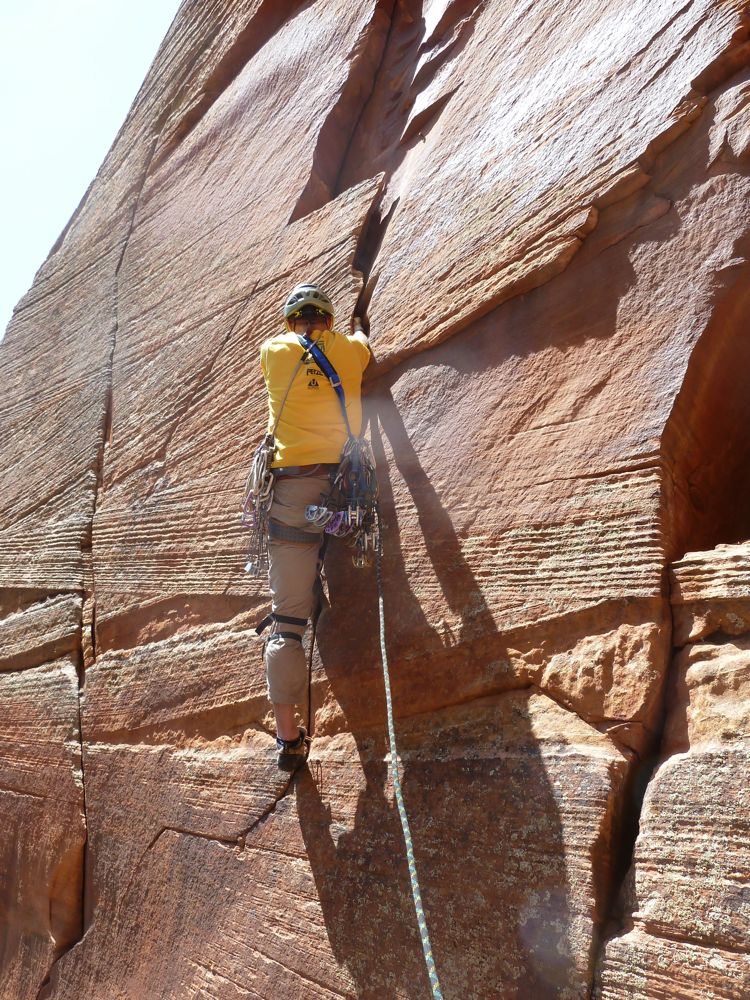
 |
| Pitch 2: 5.10 |
I led the long second pitch, straight above the belay and rated 10c. The climbing was cruxy, not very sustained, and protected well. I ran out 150 feet of rope to a huge ledge behind a little pillar. Opie jugged up quickly and after a brief discussion, we decided to switch tactics from swinging leads up the route to doing it block-sytle, in just two blocks...with Opie taking the first block. Hence, I led the short, third pitch which is 5.6, but looked quite a bit harder from the belay. It isn't though and I arrived at another good ledge below a long, right facing, shallow corner that started with a roof. Here I dug out the aiders and aided everything save just a few free moves. The pitch goes free at 5.12b, but the start wasn't possible for me and the rest was too sustained to try much free climbing. It took me a bit to get my aid mojo going, but I made steady, albeit slow, progress. It took me about an hour to aid the 130-foot pitch.
 |
| Pitch 3: 5.6 |
The next pitch is rated 11a and I left the aiders behind, assuming I'd at least be able to french-free the pitch. One of the cruxes was about forty feet up, where I had to lieback and edge with smears for my feet, protected by two cams of a green Alien. I think it would have been scarier to aid that section since then I would have had to weight that dicey cam. The rest of the pitch went well, with one pumpy section and maybe one dead-point before I arrived at the belay, having onsighted the pitch. I'd love to think I was climbing strong enough to onsight 5.11 Zion trad, but I tend to think the pitch was probably mid-5.10.
After each of my leads, Opie would shout up "nice job, dude," or something else encouraging. He was climbing well also, jugging efficiently and arriving at the belays quickly. We moved well together and were ahead of schedule. I told Loobster the earliest to expect us on top was 4 p.m. and the latest 8 p.m., if we made it at all. The Loobster's plan was to drive the car back to the campground, hang out a bit, and then take the shuttle bus back into the park and hike up the Angel's Landing trail and then the West Rim trail to meet us on top. Conveniently our route tops out about fifty feet from this trail. The Loobster would be carrying our approach shoes, a couple of packs to carry down the gear, and some water for us. What a guy...
 |
| Pitch 4: 5.12b or aid for me |
I combined the next 5.9 pitch, up some steep, cool flakes and the following "face crack" pitch into one, as it made the jugging much easier for Opie (eliminating a big traverse around the corner) and because, even put together, the pitch wasn't that long. I thought about tacking on a third pitch and I had plenty of rope for it. Opie jugged up and had to deal with the rope snagging on the free-climbing-friendly/jug-unfriendly flakes. This pitch ended on another great ledge and we chilled for a bit and then I led another short 5.9 pitch up to the top of the Toquerville Tower, where another great ledge presented itself.
 |
| Pitch 5: 5.11- |
We were now below the 55-meter headwall and the tree hanging over the summit looked so close. What stood between us and the top was the crux (C2 or 13b, C2 for us). A very thin, intimidating crack split the wall above our ledge. This was the pitch for which we brought our two sets of micro-nuts. I started by stepping high in my aiders off the belay bolt and found the going remarkably straightforward. I did use the micro-nuts, but never the smallest two. I did have to place a couple in a row a couple of times, but they set in the crack very nicely and seemed completely solid.

I made steady progress up to the Sharp Crack and then heard someone call my name. Looking over my shoulder I could see the Loobster high above me out on top of the Moonlight Buttress. He was Already there, waiting on us. The last pitch was short and went relatively easily on aid, finishing up with a couple of dicey placements in an overhanging crumbly crack. Before I knew it I had clipped the giant chain hanging down from the summit anchor, which I'd guess is there to save the tree, which you climb right through. I topped out around 3:45 p.m. Opie joined the Loobster and I 20 minutes later and we celebrated a successful climb with our copious extra water and food. We couldn't have asked for better weather. I climbed in a long-sleeve shirt and long pants for the entire route and was never hot nor cold.
 |
| Pitch 7 (for us): 5.9 |
Despite how smoothly things had gone, Opie announced his retirement from wall climbing. He decided that wall climbing wasn't for him, as it just wasn't fun. That was a bit disappointing, as I really enjoy climbing with him, but understandable. I think the soft Zion sandstone contributed somewhat to that decision, but it would have probably been the same if we were in Yosemite. That's okay, though, as there is lots more to do in climbing and in life without climbing walls. You've got to do what makes you happy.
 |
| Pitch 8: 5.13b or aid |
I'm not much of a real aid climber. I've pounded one piton in my life (on the Titan) and have only placed a handful of bolts, all anchor replacements. I've done a few hook moves in my life, but never more than one in a row. To me, a copperhead is one of the four poisonous snakes in North America (though I have clipped more than a few of them, the pieces, not the reptiles). That said, I'm pretty good with placing gear, as I have more than thirty years of trad climbing experience. For this route I never had to work at any placement. I pretty much set them and I was done. The angle was such where I could climb very high in my aiders when necessary and make a big reach to an easier placement. Using these techniques the route seemed C1 to me. All the climbing seemed pretty solid, save and secure except for that one section on the 5.11a 5th pitch. I really enjoyed this route and would do it again, because of the relatively little aid climbing.
 |
| On top! |
Zion Day 7: Jenny Peak (and her Nipples)

Photos Map
Yes, this was supposed to be the wall climb. We had racked and packed the day before and determined to launch. The alarm went off at 5:30 a.m. but while eating breakfast we were disturbed by the pitter patter of raindrops on the RV roof. Sure enough, it was raining. We decided to drive into the canyon anyway (with our special pass, obtained the day before) to check out the conditions up at the Big Bend Shuttle Bus Stop. We stopped at the Grotto to use the bathroom and there had a nice encounter with a ring-tailed cat. .These guys are so cute. They have huge, inquisitive eyes (as they are mostly nocturnal), expressive ears, and a cautious curiosity. Alas, none of us had a camera easily accessible.
At the parking the ground was wet and so were all the plants and the rock. We decided it wouldn't be responsible to climb the rock in those conditions, as you can damage the rock, which is much softer when wet. We went to go scope the river crossing anyway and found a couple down there preparing to cross. They were off to free Moonlight Buttress. Seeing them cross and head for their climb made me second guess our decision somewhat, but Opie was adamant about putting off the climb. Being a deeply spiritual person I communed with nature and actually bonded with the big red cliff above us. Together we decided caressing her precipitous slopes would be put off for another day. Besides it was colder today and wet and we could easily delay another day.

Not content to just sit around, I proposed a hike up to Observation Point, where we'd have a great view of our wall objective: Sheer Lunacy, two routes to the left of Moonlight Buttress. The Loobster, who wasn't planning on doing the wall, hadn't eaten anything that morning, thinking he'd be back at the RV in just an hour, did the 3-hour, 2100-foot, 8.5-mile hike anyway. We all just went up with nothing, as it was impromptu. We hiked from the Big Bend Shuttle Stop, as we only had a permit to park there, to the next stop down canyon - the Weeping Rock stop. Here we picked up the trail and had a very pleasant hike up this steep trail. It was still mostly in the shade, since it was just 7:30 a.m. and it switchbacked up the east side of the canyon. We passed a couple of ladies early on and had the trail entirely to ourselves. The views were indeed spectacular and after 15 minutes we headed down.

Back at the RV, after an early lunch (breakfast for the Loobster), we packed for another hike. I had decided we'd do Jenny's Peak on the east side of the tunnel, which was a 4th class scramble. Opie drove us through the tunnel and had an enjoyable scramble 1400 feet up to the summit. We also bagged two smaller summits just south of there, known as the Nipples. We moved at a casual pace, enjoying the day and saving ourselves for tomorrow. We noticed another nice peak to the east, maybe Lost Peak, and decided to turn our hike into a loop. We descended steep slabs and sandy areas down to the saddle between the peaks. Here we discovered three things. First, a sign saying not to go further south, as the area was closed for a wilderness study. Second that the route out of the notch towards Lost Peak was much steeper and most serious than it appeared when we made this decision. And, three, that tracks led north, toward the road, down the canyon. Loobster pushed for the canyon descent and I assented with just a touch of reluctance, fearing a nasty bushwhack. I knew from the topo map in my guidebook that the canyon looked pretty gentle, but there could have been wading or 30-foot falls lying down there. But I was wrong. The entire canyon went smoothly and easily and was quite nice. I turned the wrong way when we got to the wash that parallels highway 9 and led us the long way to the road, with some the bushwhacking I had been trying to avoid, but soon we were hoofing it a half-mile down the road back to the car.
Sunday, May 06, 2012
Zion Day 6: Confluence Area Cragging
 |
| Crimson King |
Photos Map
Opie arrived a bit after 7 p.m. yesterday and the weather report looked grim: an 80% chance of rain. So we didn't expect much out of the day. We had originally planned our wall climb for this day, but moved it to Friday because of the forecast. It wasn't raining in the morning so I was running up canyon by 7 a.m. to get in 9 miles. When I got back, after second breakfast, we piled into Opie's car and drove up to the trailhead at the last turn-out before the tunnel. This was quite a bit easier than the biking approach we did two days earlier. The Confluence area has some of the most moderate climbing in all of Zion, including a 5.7 sport route. I offered leads to my partners, but they were content to let me put up the rope.
We started by climbing a one-pitch 5.7 crack (had about 3-5 total moves of 5.7) called Ghetto Booty to a big ledge with a bolted anchor. From here we climbed in succession Barely Legal (5.7, sport climb), I'm No Sports Climber (5.9, mostly bolted, two pieces of gear), the Battered Wright (5.10+, sport climb), and The Tribute (5.10, sport climb). Of these the best route is the Battered Wright. It looks spectacular and everyone agreed was a blast to climb. I thought it was quite a bit easier than 10+, maybe 10a/b. Opie thought there was a touch of 10c.. The Loobster felt it had to be 5.9 because he didn't fall off it!
The first three routes all allowed us to lower back to our ledge with our single 60-meter rope, though the Battered Wright did req uire us to start from a ledge twenty feet higher. The Tribute was a different deal. Since it was rated 5.10, we figured it would be easier than the Battered Wright. This is not the case. The Tribute has an intermediate belay just forty feet up, but this isn't used to make the descent easier, since you can't easily rappel back to it. I suspect it is just so you don't need so many draws to climb it. I started up this route with 16 draws, intent on combining the pitches and fell 5 or 6 draws short, having to skip some bolts. I found the first section very hard with a huge reach left to a bucket, but then I had to heel-hook my right foot, not a move I do often, outside of the gym anyway. I made the move, hung on to clip the next draw and then burned out before I could continue. I hung from the rope. I think this section was 5.11.
After a brief rest, I moved on and made the first belay. Since neither Opie nor Loobster wanted to follow this pitch, I figured I just put the two pitches together and lower off. This would have been a good plan if the route wasn't 150 feet long... The climbing on the upper section was fun, steep, super well protected and not very hard (5.9?), but it had so many bolts, that I ran out of draws and had to start skipping the bolts. Also, I ran out so much rope and the route ascended at an angle that it was going to be impossible for me to lower off and clean the route. Someone would have to follow it.
Opie stepped up and tried in. He cruised past the crux section with a couple of quick pulls on the draws and rambled on up to the top of the pillar where I sat waiting for him. We rapped once down to the anchors at the top of the Battered Wright and then from there back to the Loobster. I then led around the corner to the anchors at the top of Crimson King and we rappelled to the ground.
I then worked Crimson King a couple more times, eventually almost getting it completely clean, but missed a foot switch and knocked myself into a barndoor fall. This is a really fun crack to work. I'll probably be back next year with a goal of redpointing it.
Opie and Loobster weren't interested in giving the crack a try, so once I was spent, we packed up and headed for beers.
Zion Day 5: The Watchman

Photos Map
The Watchman is an awesome summit that hangs right over our campground and the Zion National Park Visitor Center. I've wanted to climb it for years, but it had never bubbled up to the top of the list, mainly because of the nasty looking approach. But now that we knew the good approach up to and over the Johnson Ridge, which is the same approach to the Watchman, that barrier was removed.
I took yesterday off from running in order to be well rested for today's killer workout of 5 x 1200 meters. I was out the door early warmed up running up canyon 2.5 miles to the Confluence Shuttle Bus Stop and then road that to end of the canyon. I did the intervals coming down the canyon and then jumped on the bus for one stop and then ran the rest of the way back to the campground, getting in about 9.5 miles.
After a second breakfast (like all good hobbits, I eat two), the Loobster and I took the town shuttle bus the other direction and re-traced our tracks over the Johnson Ridge and down into the wash. This time, though, we went directly across the ridge and started up the Watchman.
We had previously scoped our the route from the top of the ridge. What we saw was dauntingly complex.
There was one big gash amongst many weaknesses, but this gash ended in a nearly vertical drop of over a hundred feet to the wash. There wasn't an obvious way up there, but we did see a possibility off to the left. We hiked up and left a bit, around a beehive like buttress and then did a cool, airy traverse on a tiny ledge back to the right, where we found a fixed line leading up a wall. Climbing this wall without the benefit of the line, it felt like easily 5th class, maybe a touch of 5.2.
Above the wall, we entered the big gash/gully that we scoped from the ridge and followed it easily upwards, occasionally directed by cairns. The route is always "the easiest possible way at the time." It just all goes so nicely. We climbed up a steepish slab and down a bit on the other side and then up into a narrower gully that led to the second and final technical section, which was about ten feet of steep 5.5 stemming.
 |
| Above the second technical section. You don't have to climb through this tree, but traverse in above it, from the left. |
We then followed Courtney's description of taking a corkscrew route around to the left until you couldn't go any further and then headed up to the summit. On the way down we short cut this a bit and when you think you can head upwards on steep slabs, you can, as we came down that way.
 |
| Eating lunch on the summit. |
We made the summit in three hours and ate and drank on top for 15 minutes before the threat of rain chased us away. We had a few sprinkles on us and I thought we might be in for a soaking, but it never happened. Still it spurned me on for an efficient descent and we made it from the summit back to the shuttle bus stop in just 90 minutes.
 |
| Johnson Mountain from the Watchman. Our route from two days before follows the ramp from the far left up and right |
Zion Day 3: Johnson Mountain

Photos Map
Courtney Purcell has a funny way about his descriptions in the guidebook. They lack a certain je ne sais information. For instance, he's favorite phrase is "route find upwards." I think for Johnson mountain he says something like this: "Figure out the best way to approach the notch, taking care not to violate private property and head to the notch. Once through the notch drop into the wash and head down it for a quarter mile and climb out of it at class 3-5 and route find upwards." He loves that line: "route find upwards." Another favorite is "follow the easiest line." Good thing we had this guidebook to help us. On the really complicated mountains, of which this is one, he instructs "route find upwards, really well."
All that said, this is a very complex mountain on the east side. It would be difficult to give detailed directions and I can't do much better than Courtney, but I can do better. This climb has a remarkably small suffer factor compared to other Zion summits, like Bridge Mountain or West Temple, as there is little bushwhacking (if you use the best start) and little dangerous rock (also if you find the best route). This is recommended for those adventurers with good route finding skills and a nose for the summit. Others might be frustrated.
I went out for a 6-mile run before our ascent and I found the trail indicated in the guidebook to approach the mountain, but I also found a much better trail that began from a fancy neighborhood as well... See the map for how to get to this good trail. We did have to walk past a private property sign when we crossed the bridge over the Virgin River into the neighborhood, but we were walking on a paved road. We did this twice and were not bothered at all.
We followed the trail I found up to the base of the Johnson Ridge - the ridge leading north from the summit of Johnson Mountain over to the notch between it and the Watchman. On the way up to this wall I almost walked into a rattlesnake, but those snakes are so accommodating. They also let you know when you are in danger of an unpleasant encounter. A few feet from the snake the angry rattling sound alerted me to alter my course, after taking a photo.
 |
| In the center of this photo is a rattlesnake |
 |
| Steep, scary slabs |
 |
| The crux bush section |
We then followed weaknesses up and right, trying to get on the ledge that cuts from right to left across the entire face. Getting to this ledge proved to be the crux, as we had to climb steep slabs via from big reaches to holds and then up very bad rock to a bush, where we climbed right through it to grab a pre-rigged rappel sling. Above here the going dropped to 3rd/4th class and a couple hundred feet higher we hit the ledge and traversed it, mostly easily, up and right until we couldn't go right any longer. Then we went back to the left and were soon on easy hiking terrain and trying to figure out which of the three summits was highest.
Thankfully the easiest of the three was the highest and we found a cairn and summit register on top. The recorded only six ascents since it was placed on April 23, 2006, with the last one being on January 6th of this year. Cool.
The descent had us worried and we tried to find a way around the bush/crumbly rock section, but eventually reversed it. It is dangerous, but we went as slow, solid, and as careful as we could. Once down that the rest of the route was easily reversed, including the steep section back into the wash.

The rest of the descent went nicely and we got back to the RV 4:30 p.m. Our days were getting shorter and shorter. And we were loving it!
 |
| The summit |
 |
| On top! |
The descent had us worried and we tried to find a way around the bush/crumbly rock section, but eventually reversed it. It is dangerous, but we went as slow, solid, and as careful as we could. Once down that the rest of the route was easily reversed, including the steep section back into the wash.

The rest of the descent went nicely and we got back to the RV 4:30 p.m. Our days were getting shorter and shorter. And we were loving it!
After-advenuture weight: 156.0. I'm shrinking! More like, I'm shriveling up... Thankfully the 90-degree days we had been having would end today.
Zion Day 4: Smashmouth

Photos Map
The main objective for today was to climb Smashmouth. The Loobster and I had rapped down this route on our descent from Take Back the Rainbow last year and I thought the rock and the climbing looked great. It was rated in the Super Topo guidebook as 5.11+ but it looked easier and I figured most of it has to be easier, as normally that rating would be enough to keep me away. Having just finished my winter rock gym stint, I was at my strongest and wanted to test myself on this crack.
We biked from the campground up to the tunnel wearing packs heavily laden with climbing gadgets. I dumped my pack at the trailhead and went back down a half-mile to give Loobster a hand with his. We hiked around to the Confluence area and decided to do a pitch or two as a warm-up. We didn't want to delay too long, though, as we wanted to do the route while it was in the shade. The wall it was on faced west, so we did have some time and it worked out well, as I only entered the sun on the last pitch.
I led a 4-bolt mixed route (a couple of cam placements, as well) called Salty Dog Arete. It was rated 5.9, but felt soft for the grade. Whether I was just climbing strong or the routes were over-rated, I didn't know, but I hoped it applied to Smashmouth as well. The Loobster followed it easily and in rappelling off we had ourselves a nice toprope over Crimson King - a striking crack line rated 11b/c. The start of this route is so thin that you'd half be a very small person to get your fingers into it. I fell off a number of times, as I tried to work out a way to climb the start, up to where I could get my fingers into it. I found a very powerful lieback sequence where I was on the very edge of barndooring off. In fact, I did a number of times. Above this move, I climbed it cleanly, though very near my limit. The climbing was superb and very fun, at least with my fingers taped nicely for protection.
We pulled the ropes and headed for Smashmouth before my psyche failed. I had hung all over a route rated 11b/c and now headed to a route rated 11b on mountainproject.com and 11+ in the SuperTopo guidebook we carried.
Smashmouth is four short pitches, with the first one being the longest at 100 feet. I climbed up a 5.6/7 corner to a ledge and then climbed a slanting tight-hands cracks rated 11a. It was hard for a move or two, but I had the power and soon it was over and I was on another ledge. I moved left and up a steep 5.9 crack to a belay on a nice stance from two bolts.
The Loobster was purely here to support me and had no desire to try and free climb the crack. This was his choice, but I think he would have done quite well on this route. Nevertheless, he jugged up the rope and soon I was leading the next pitch, which started with a 5.10+, bolt-protected, face climbing section to a nicely featured crack. I felt the face climbing had one semi-hard move and the rest of the pitch felt more like 5.9 or maybe 10-. The pitch ended at another good stance.
The third pitch was a continuous of the crack, but it was much thinner now, mostly protected by 0.4 and 0.5 Camalots, with some 0.75 Camalots. I had four of each of these cams. The climbing was really fun, with technical, smears for the feet mostly and the crack alternated from sinker locks where I could place gear to marginal jams where I wanted to move off them quickly.
I gained altitude steadily but was getting more and more pumped. I thought the belay was at a certain point where the angle rolled back a bit, but there were no bolts. I continued upwards with no belay in sight. The Loobster called up asking how close I was and, looking up,I saw no end in sight. Then I noticed the bolts just off to my right. I was there! I had such tunnel vision I failed to notice the bolts just two feet right of the crack.
The final pitch was supposedly the crux at 11b and I found it to be the crux. At least, it proved to be the only place I fell off. I made progress pretty nicely up until about ten feet from the final anchors. I was getting tired and had to lock off a hand jam for a huge reach past a thin section of the crack to a slopey pinch. I just didn't have it and fell off. After a brief rest, I pulled the jam even lower and reached a bit higher. This time the pinch felt reasonable and I finished cleanly to the belay. What a great climb!
I had the Loobster lower me from from the top anchors and I cleaned the pitch on the way down. This saved the Loobster from having to jug another pitch, since the descent is to rap the route. Three more short rappels and we were back at the packs. We hiked back to the bikes and the coasted down the hill back to the campground where beers, chips, and salsa awaited us.
Smashmouth
After-advenuture weight: 158.6
First Flatiron with the Koskis

Photos Map
Today I took my sister's entire family up the First Flatiron. Sheri and Derek came along as well and proved quite valuable in helping out with the climbing. I decided on the First Flatiron as an objective since it is so iconic and it would be cool for them to say that they'd climbed it, as it is so visible from all over Boulder. The problem was our group was large: eight people. And we only had one climbing leader: me. So, I opted for the shortest route on the rock, which is the 5.4 Southwest Face, the usual downclimb off the First, if you are soloing it. This involves a pretty long hike, gaining about 1500 vertical feet, but everyone was a strong hiker and there were no complaints as we chatted up the trail.At the base, everyone put on a harness. I have tons of harnesses and everyone got a reasonable fit except for Sami, but she was a trooper and didn't complain at all. It fit good enough to be safe, though not perfectly comfortable as her leg loops were too big and sagged down.
I only brought two 60-meter ropes, as more would be too much of a pain, but it did require a bit of simul-seconding (more than one second climbing at the same time on the same rope) for our first-time climbers. Also, this face was taller than I remembered and with the downclimb tree gone the route is longer and traverses more. I had to break up the route into three pitches to minimize the simul-seconding and this made for a very cramped first belay. I had climbers strewn all over the rock, some clipped into my anchor and others just clipped into other climbers, who were in turn clipped into the anchor.


While climbing the face we did have five people downclimb past us, including my friend Kirk. They were all cool and waited on us somewhat and climbed by carefully and watchful of our newbie climbers.
I dashed up the second pitch to an big eye-bolt anchor and a lot more space. This pitch was mostly easier, though steeper and airier, but it did have a hard section at the start that gave some of the girls some pause, but none more than Brookie. She was really second guessing her decision to do the climb and called for more tension on the rope. The problem was that she was tied to Kraig above, and he wasn't at my belay yet. He knew the score and hung on particularly hard, bracing for Brook to possibly weight the rope. I had them both on belay, but Kraig would have been pulled off the rock and sideways a bit if Brook had really fallen off. Thankfully she got it together and moved up, allowing Kraig to reach the safety of the eye-bolt and me to put Brook directly on belay.

Brook then made it the rest of the way without much trouble. Everyone shivered at the belay, as we were all in shorts and all wishing we had long pants...and down jackets! Sheri climbed so fast that Brook commented on the rate at which I pulled in rope but thankful that we'd be moving soon.
I led up to the summit, up the final steep headwall and they followed one by one. Here I could put some direct tension on each climber as they were close to me and directly below me. Everyone did great, though Missa took one look at the wall and said, "That's impossible to climb." And she did it. Derek and Kraig cruised it easily, like they had it wired, but neither climbed it before. Kraig had been climbing with me a couple of times before, but long ago, and Derek had even climbed the First Flatiron twice before, but by different routes. So Derek has now climbed the First Flatiron by three different routes. Sheri easily climbed the last section, looking very relaxed. She has climbed quite a bit but the last time was a couple of years ago.

After photos on top, it was time to lower everyone 100 feet down to the ground. Derek went first to demonstrate to everyone the proper technique. Sami went next and started absolutely perfectly, without any fanfare, but lower down she got to a tiny ledge and stood on it. Now she had to lean back all over again and it was tougher now because she wasn't as close to me. She sucked it up, though, and set a great example for the rest of her family.

Missa was next and she also did great at the start, but then had a moment lower down where she got frightened for just a bit. Descending is frequently the scariest part of climbing and it was for all the girls, but with good reason. Leaning back on a rope over a 100-foot drop is so unnatural that the body and mind rebel against it. I was so impressed how quickly they all went over the edge and how well they all did on the climb in general.

Kraig went next and it was routine and easy for him. I expected Brook to be the toughest, but she did amazingly well. She was completely composed and, while maybe not exactly relaxed, very much in control. Getting lowered like this is the ultimate act of trust in the person on the other end of the rope. I was glad they all trusted me enough to get them down safely. Sheri descended easily, as she has done this quite a few times before.

I packed up the second rope and the gear and then rappelled to the ground. We had a great time hiking out, chatting as we went. I think the first Koski Klimb went well and hope to do a few more of these throughout the summer, though possibly with more support climbers or break up into two separate groups.
What a great group. The weather was cold and windy the entire time, but there was no whining, no complaining. The climbing was steep, scary and new to them, but there was no freezing up, no requests to go down. Everyone was super positive and super pleasant! It was one of my favorite days in the Flatirons. Love it!
Saturday, May 05, 2012
Zion Day 2: Deer Trap Mountain South Buttress/ Hidden Canyon Descent

Photos Map
Today, I weighed in at 162.2 pounds. Probably artificially light due to dehydration, but it gets worse. I ran 12 mlles this morning, up Zion canyon and back. Then we hitchhiked through the tunnel, climbed the South Ridge of Deer Trap Mountain, mostly casual with just one very dangerous pitch. We hiked over to the north side of the mesa and descended Hidden Canyon (6 rappels), finishing up by hiking down the Observation Point Trail to the Weeping Rock shuttle bus stop. I drank all 70 ounces that I was carrying and ate all my food. I was feeling fine, still moving well, but knew I was dehydrated some since I could have drunk double what I had.
Back at the RV and before showering, just for grins I hop on the scale. It read 157.0.... I didn't feel weak, though I sure didn't want to go running. I drank and ate copious quantities tonight. I hope I didn't over do it. I sure got in my exercise today. I ran for two hours and then we were out adventuring from 10:20 a.m. until 6:30 p.m.
The approach to the South Buttress is just plain fun. It goes up a beautiful wash with steep walls on both sides and then we break out to the west, up slickrock slabs to a saddle at the toe of the buttress. We then just frictioned up the slabs in our sticky-rubber approach shoes. It gets pretty steep, but we're experienced slab walkers.
A couple hundred feet before the top the buttress becomes nearly vertical and we scooted around to the right on ledges and did some steep scrambling on loose, crumbly rock. When it got too steep for our comfort, we roped up. We carried our ultra-light harnesses and two 30-meter, 7.8mm climbing ropes. Having two short ropes allowed us to divide the rope and carry very small packs. I led up steep ground to the lip and had to negotiate past a large, loose block.
Once on the top of the cliff we had to hike cross-country a bit to the true summit, which is just a bump on the mesa and looks like nothing once up on the plateau, because this really isn't a mountain, but a point on the edge of a large plateau.
We soon found the trail on top and followed it east for a mile or so. I was using a GPS app on my phone to track out location and we dropped into the very top of Hidden Canyon. This canyon runs south-to-north and directly east of the Great White Throne. I had been up the canyon pretty far a couple of times, as there is an official trail that leads from Zion Canyon up to the end of Hidden Canyon. We followed it all the way down to this trail, doing 6 rappels in the process, one of which could have been avoided with just hiking. We scrambled down a number of other obstacles.
It is so convenient to then just walk out to a shuttle bus stop and ride that back to our campground. I was thankful to get back a couple hours earlier than the day before.
Zion Day 1: The Organ

Photos Map
We got to the RV park a bit after noon, checked in and got the RV set-up. We threw the packs together and hiked up to shuttle stop and rode it up to the Weeping Wall stop. The Super Topo guidebook doesn't even list the route we were planning on doing, the Southeast Chimney, but it was in Courtney's Zion Summits book. The route weaved up through the cliffs on the north side, supposedly at the 5.6 level, and provided the easiest path to the summit. We brought trekking poles and Tevas to wade the river, which wasn't too horrible. It did involve about 5 seconds of intense pain on the other side, but then our feet instantly became comfortable again.
We left out Tevas and poles down low and we should have left our packs. Taking these up a route with tight chimneys is just...not wise. I guess I figured since it was only 5.6 a "tight chimney" would suddenly be wider whenever I needed it to be. That didn't turn out to be true. We found the start and geared up. The first pitch had an option of climbing the chimney or the 4th class wall to the left. I chose the latter option and it went fine, though at a tougher grade. Above was a tight 20-foot chimney and I had to remove my pack for this and would for most of the remaining chimneys. I found this chimney to be a pure back/knee chimney, which wasn't very comfortable in the shorts I was wearing. One skinned knee later I was on a good ledge and belayed Loobster up, hauling up both packs.
The next chimney is tight but supposedly only 4th class. It turned out to be very strange. The chimney had a sandy floor to it, acting as a ramp and until the very end I was standing on the ground. The probably was two steps in the chimney, only about two feet high, but the chimney was so tight that it proved quite difficult to step up onto these ledges. Strange stuff. The chimneyed opened up a bit and became vertical and some easy moves led to a belay on a chockstone. I had the Loobster untie from the rope so that I could toss down the rope on the outside of the chockstone to haul up the packs. Then I tossed it down again to belay him and dropped him a loop on the other side of the chockstone when he got near it. So many shenanigans!
Next was the tightest chimney of the route. At first I took off my pack. Then the rack. Then my helmet. Then my glasses! Okay, that last one was a mistake. They landed softly fifteen feet below at the bottom of the chimney and had to I descended to get them, lest I end of on top the iMax theater in town instead of the Organ.
I was baffled by this chimney to begin with. It seemed way harder than 5.6, but then I just tunnelled all the way to the back, climbed easily upwards and then made my way back out to the edge where I was able to traverse over to a ledge.
The next pitch was more of a corner system than a chimney and I was able to wear my pack all the way. This was good, as I was getting tired of hauling the packs and it was making things slow. The final pitch was a committing lieback move with no gear, but it wasn't too hard.
We dropped the packs an ropes, and scrambled steep, 4th-class terrain to a great summit.

On the descent, the Loobster knocked a big rock off. I was below him but was able to dash off to the side. Miraculously, the Loobster didn't fall and we avoided dying on our first day in Zion. Awesome!
We did a couple of single rope rappels and then scrambled down to the last rappel, which was 170 feet. Back on the ground we bushwhacked around to pick up our poles and Tevas and re-crossed the river. We didn't get back to the campground until 8:30 p.m. That made for a long first day, but we already had a new Zion summit.
We did a couple of single rope rappels and then scrambled down to the last rappel, which was 170 feet. Back on the ground we bushwhacked around to pick up our poles and Tevas and re-crossed the river. We didn't get back to the campground until 8:30 p.m. That made for a long first day, but we already had a new Zion summit.
Subscribe to:
Posts (Atom)