Saturday, September 24, 2022

The Northeast Buttress of Mt. Slesse with Derek


I was bruised and battered
I couldn't tell what I felt
I was unrecognizable to myself
Saw my reflection in a window
And didn't know my own face
Oh brother are you gonna leave me wastin' away

                                 - Streets of Philadelphia, Bruce Springsteen

While I might not yet be too old for big alpine climbs, I do seem to be too clumsy for big alpine descents. 

I bought my first copy of “Fifty Classic Climbs of North America” back when I was in college in the early 80s. This book directed my climbing for the first twenty years. Then for at least a decade, I ignored them. I’d done most of the ones that were in my wheelhouse and turned to other things like doing Longs Peak and the Yellow Spur over and over ad nauseam. But now that I’m older, I took a serious look at my climbing bucket list. There is no time to waste. 

Last year, Derek and I went to Slesse, but we didn’t even attempt the NE Butt, as the weather wasn’t conducive to rock climbing. Perhaps we should have canceled the trip, but I wanted to go see this mountain. With rain expected, we started up the descent route on the west side of the peak and climbed up one of the steepest trails I’d ever been on. It was a 50% grade for thousands of vertical feet. We got within 500 feet of the summit and onto technical ground when the rain started. We turned back.

This year, when the weather looked really good on a weekend, I booked my ticket and Derek picked me up at 5 p.m. at the SeaTac airport on Friday. We drove the three hours to Chilliwack (a pretty chill place but definitely a bit whacky) and then on up the rough road towards the trailhead. At 9:15 p.m. we came across a minivan crosswise and blocking the entire road. They were in the midst of an Austin-Powers-ish 23-point turn. The road ahead was too much for their soccer-mom-mobile. We decided to stop as well, though Derek’s CrossTrek could have certainly made it, we didn’t want any stress and still needed to pack for tomorrow.

The only problem with this decision was that we’d have to put up our tent directly in the middle of the road, as it was the only flat spot. We hoped that no one else would be driving up this road this late or even early in the morning. This was Canada, where a popular climb means it’s done more than once a year. We were wrong about the traffic, though.

The couple in the van was headed to the NE Butt as well but immediately told us that they were planning a 2-day ascent. This is the more common way to do this route because the approach is long and arduous (MP suggests four hours), the route is 24 pitches, and the descent is very long and very complex. I figured I was about the worst climber that could do this route in a day, but doing it onsight would make it even more difficult, as a mistake of any length would probably mean a bivy. We carried two emergency shelters with us and I thought the chances of using them were very good, maybe 80%. If we descended the way we came up the year before, once down we’d still have 20 kilometers of walking to get back to the car. There was another way down, though. 

The usual descent from Slesse was something called the Crossover Descent, but a big landslide took out a section of that route, making it impassable. A couple of years ago, some guides put up a route called the Crack of Noon Club. This climbs up a buttress to Crossover Pass. They equipped the route with 11 bolted-chain, rappel anchors, which makes the Crack of Noon Crossover descent possible. This descent isn’t a gimme, though, and we didn’t know anything about it. At least we knew the west side descent and that it was entirely on a trail, once we descended the top 600 vertical feet. We’d decide later.

We packed our gear, which was mostly a double rack to #2 Camelot, a #3, a #4 (used 3 or 4 times), a full set of stoppers (heavily used), two Micros (used one once), and 13 alpine draws. We took one 60-meter rope, though we knew a 70-meter was handy on some rappels, I couldn’t stomach carrying a rope so long. A 60-meter worked out fine, though we did have to do some down climbing off of a couple of rappels.

Once packed, we set up our single-walled First Ascent BD tent. This isn’t the best choice for the northwest where there is so much moisture in the air even when it hasn’t rained, and the dew point is high. In the morning the inside walls of our tent were damp. It was no big deal but not ideal. 

Before we could even get into the tent, a truck came up the road and we had to pick up the tent and move it to the side. We’d see these two guys the next day and spend most of the day with them. Once they were by, we moved the tent back into the middle of the road and hopped in around 10:15 p.m. with an alarm set for 3:50 a.m. Just after the alarm went off, the tent was completely lit up by headlights. Another truck was trying to get up the road. We hurriedly pulled on our shoes and jumped out of the tent to move it out of the way once again. The guys in this truck were headed for another cool mountain: Rexford. They said Slesse was on their list. Being from Chilliwack, they’d have ample opportunity to wait for ideal conditions.

We wolfed down a cold breakfast and were hiking before our goal time of 4:30. I thought we had close to a mile to the trailhead, but we arrived there in only a quarter of a mile. Cool. We started up the narrow, twisting trail, crowded closely by vegetation that was soaked with condensation. I was excited to see two salamanders on the trail. The moist conditions suited them but the cold temperatures made them immobile. 

By the time we got to the Propeller Cairn at the end of the trail, my pants, socks, and shoes were completely soaked. It was only in the 40s at this point and wouldn’t get above 55 degrees all day. I don’t think my approach shoes fully dried until Monday. 

The north face of Slesse loomed above us, split by three buttresses with two glacier-carved cirques between them. We had to cross slick slabs to get to the middle buttress, where we ascended steeply to a notch in the ridge and then down the other side on very slippery 4th-class terrain. It was an introduction to moss/lichen/rock climbing. Vegetation is a feature on this route.

Walking up the smooth granite slabs to the base of the wall, I thought of the upper slabs of Snake Dike, as the angle and rock were quite similar. That’s high praise of rock quality, I know. Alas the route itself has no rock remotely as good as these approach slabs. 

In the middle of this slab was a huge chunk of a glacier. This chunk was the remnants of the Pocket Glacier that fills this cirque in the winter and spring. It seems strange to call something a snowfield that disappears every year a glacier, but I think it is a glacier. It builds up enough ice to flow and crack with crevasses. Climbers wait for the Pocket Glacier to slide down this granite ramp before climbing this route because otherwise, you are crossing directly underneath it and very close to it, meaning if something falls off you will not have time to avoid it. In late September it was long gone. 

Speaking of late September, this isn’t the ideal time to climb such a long route, due to the lack of daylight and colder temperatures (the high was 52 degrees), but much more important is to have a dry forecast. There is so much lichen on this route that I imagine it would be nearly unclimbable when wet. Our forecast was good. We had to make an attempt. I knew I was in for adventure and all that entails which means stress and discomfort. I don’t yearn for challenges like this as much as I once did and I felt that uneasy. Once we got up reasonably high, we’d be committed. There isn’t an easy way off this mountain. There are no fixed belay stations anywhere on this route and hardly any tat. If we got high on the route, we’d have to top out, but there is no walk-off on this mountain. Every route to the summit is a technical route.

As we headed up the slabs to the ByPass Ledge, which avoids the first six pitches of the Direct NE Butt (10c), we heard and then saw a pair of climbers. They were roped up and simul-climbing along the ledge. We quickly gained the ledge and seeing that it was really just 3rd and 4th class, continued unroped in our approach shoes. The exposure grew significantly with upward movement as we gained the buttress itself. We could already look down on a thousand feet of vertical. 

We caught up to the follower just as we started heading up the buttress proper. His name was Cory and he was a rock guide from Squamish. His partner was also a guide and his name was, and this is his true name on his birth certificate, Tigger. I couldn’t resist asking Cory if his partner’s head was made of rubber and his bottom of spring. But he didn’t know what I was talking about, so I had to sing it to him:

The wonderful thing about triggers
Is tiggers are wonderful things!
Their tops are made out of rubber
Their bottoms are made out of springs!
They're bouncy, trouncy, flouncy, pouncy
Fun, fun, fun, fun, fun!
But the most wonderful thing about tiggers is
I'm the only one

Cory and Tigger were the guys that drove by our tent the night before. 

We moved up to the right of these guys to a small perch in trees and dirt with hardly any level ground. I found a sling anchor here. We geared up, being careful not to drop anything. I asked Derek if he’d like to lead first or me. He said I should start leading “just in case any passing was necessary.”

I climbed up steep ground, but most of it was dirt and trees with some rock. We were still really working our way up to the cleaner rock. I ran out all the rope and decided to belay Derek up rather than simul-climb because of the drag of 60 meters of rope. If we were to simul-climb we’d need to shorten the rope, which we really never did. Instead, I did long pitches and by then I needed more gear anyway.

The climbing on the lower half of the buttress is low angle, broken, and rich in vegetation, meaning lichen covered the rocks and moss filled the cracks. Some cracks were clean and others had gardened-out spots for placements. The climbing was probably 5.6 or easier but insecure because of the greenery and a bit freaky because protection was sparse. 

I stayed in the lead and we followed Cory and Tigger up the route. We were both using the MountainProject written description, but I didn’t need to refer to mine, as I just followed these guys. They were both really friendly and we got along great. Tigger was leading everything on the first half of the route so I got to know just Cory. They had a 70-meter rope (for the descent) but were climbing on just 35 meters of rope and simul-climbing with Micros. This simul-climbing seems to be catching on. Pretty soon people will be doing it in Eldo!

Despite not simul-climbing, we kept up with them and sometimes even had to wait on them a bit. But they were doing all the route finding, so we didn’t mind at all. I was worried about the descent and secretly hoping we could join forces to figure it out. Or that they could come to pick us up if we went down the other descent.

From the moment we left the car, we’d been moving nearly continuously. I didn’t even sit down to belay but once or twice. Derek and I are very efficient at the belays. Once he arrives, we re-rack gear, get him anchored, take him off belay, put me on belay, and I’m off. Rarely does this take more than a minute and never more than two. I liken our partnership to a band that is “tight”, meaning all working together in the exact same rhythm.

The crux of the lower half of the route is a 5.9 pitch just below the halfway bivy ledge. It was by far the steepest pitch yet, but it went nicely on some big holds and good gear. It was by far the best pitch yet. Derek liked it because “it was mostly rock.” That’s a strange comment to make for a rock climb, but it was appropriate for this route.

At the halfway bivy ledge, which is huge, we’d done 12 pitches with 12 to go. It was just 11 a.m. The route above steepened and the climbing got harder. Above us were three more pitches of 5.9. I asked Derek if he wanted to take the top block and he hesitated. He said he wasn’t feeling that great about the climbing. I got that completely because I was a bit put off by it as well. In Italy, Derek was keen to be in the lead for all hard climbing. He asked how I was feeling. I told him I was happy to keep leading. I like leading and I was already used to climbing and had my lead head going. He said that he wanted to lead some but maybe a bit further up.

I ended up leading the rest of the route and we never talked about switching leaders. Just like our change-over coordination, we know each other so well that there was no need for discussion. I knew Derek would speak up if he wanted to lead. Frankly, this climbing is my specialty: semi-runout, moderate, tricky-gear-placement, alpine climbing. I’d have included ‘difficult route finding’, but the guides were doing that all for me. If the climbing was harder and cleaner with more solid gear, Derek would have been in front, placing all the gear for me to grab and pull on. He’s done that before. Still, it was good to know that I can still be useful and a valid partner to my much younger, much stronger, much fitter son.

The 5.9 pitches above were steep and interesting. One had a few precariously jammed flakes that were necessary to use. It was freaky to pull on them, but they didn’t move. Another pitch was runout and devious. The last real pitch was rated 5.7, but this passed by some rock that was just barely attached and too big to trundle for fear of hitting Derek or chopping my rope. I felt this was the crux pitch, mentally. 

There is a 4th class escape at the top and I took that. I got incredible rope drag going hard to the left, down, and then up again and Derek had to simul-climb below me to free up the rope. But it got me to the summit and soon Derek had joined me. It was just before 4 p.m. Cory and Tigger were nearby, packing up their gear. Derek and I ate, drank, changed shoes, stowed the rack, coiled the rope, and were soon headed down, following Cory and Tigger.

We scrambled down some scree and then across exposed ledges, up to a notch, and steeply down the other side to some rappel slings. The guides went down first on their rope. They moved surprisingly slowly on rappels, as each set up a prussik backup each time. They weren’t that slow. I’m just used to guides that move ultra-efficiently. They pulled their rope and we rapped down next. We had to do an extra short rappel due to our 60-meter rope.

More scrambling and more exposed climbing led us to another rappel. Then we traversed further around and decided to rappel what the guides were down climbing. We did two more rappels here with some short, fifth class, heads-up down climbing to get to the next anchor. Then it was hiking and scrambling in loose gullies, over notches, and along the ridge. Up, down, up, down. At one point, I slipped off the narrow trail and fell to my knees. Then my hands slipped and I literally planted my face into the rocks. Thankfully, I bashed my face into my cheekbone, which seemed way better than knocking my teeth out or breaking my nose. It really rang my bell though. Derek was right there and knew I was hurt. I laid there for a while just trying to get my wits about me. After less than a minute I stood up and moved on. We had a long way to go and little daylight left.

We kept traveling the ridge, up and down. We topped out the highest mini-summit and had to do two more rappels to get down into another loose gully. In general, I was always last here, as I’d pull the rope, coil it, and put it in my pack. I always encouraged Derek to just keep moving once he was off the line so that he could either follow Cory and Tigger or lead the way and find the route down. Derek did a great job of this all the way down.

Eventually, we got to Crossover Pass and the first rappel anchors of the Crack of Noon Club route. From here it would be 11 single-rope rappels down to the talus, all on 2-bolt, chain anchors. In this last section, I caught and passed Tigger who seemed to be fading a bit. This set Derek and me up to go first down the rappels. Cory asked if it would be a good idea to have the first guy down bring the second rope and set up a rappel below, but I nixed that idea. It didn’t make any sense for this many rappels, as you’d then have to pull the top rope, coil it, and transport it down to the third rappel. It made much more sense for us to descend as two teams of two and just pull the rope through the next anchors when we pulled it down. Plus, Derek and I would simul-rappel the entire thing. We’d known from the earlier rappels that we were faster than the guides.

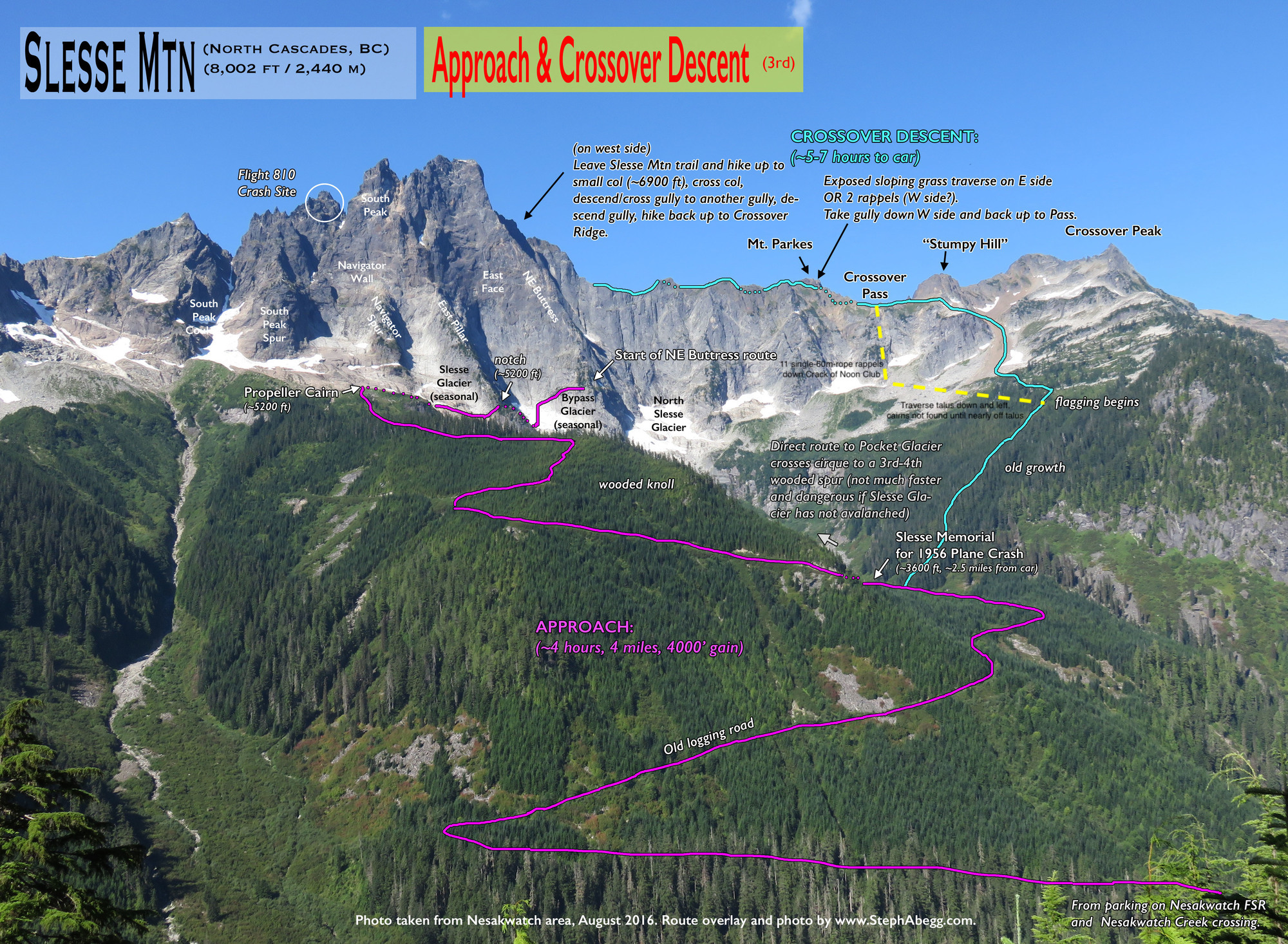
This shows the descent we took, with the dotted yellow line being added to this photo by me.

Derek and I both got our Grigris on the rope and started down together, but not before getting our headlamps out and getting Cory’s phone number, as we suspected this might be goodbye. Our descent went super smooth. We have a lot of experience simul-rappelling. We count down weighting and unweighting the ropes. We knot the ends. We clip into the anchors…mostly. After maybe the second rappel we had to turn on the headlamps. Here simul-rappelling really helped us, as we could scan a much wider area on the descent in search of the rap anchors. Sometimes Derek would spot the anchor and sometimes I would. Each time we predicted where the descent would go and tossed our ropes in that direction. We always made the right decision. A descent this long, sight unseen, in the dark would normally be quite stressful for me, but here the angle wasn’t very steep and ledges were plentiful at each anchor. We counted down the 11 raps and were soon on talus.

Here, we finally took an extended break, though by extended I mean 15 minutes. We got to finally strip off our harnesses and helmets. We ate a ton and drank even more. We’d carried three liters from the car and still had plenty left due to the cool temperatures of the day. We had one crux left: finding the trail. In the Pacific Northwest, you cannot descend through the forest without a trail. Something that would take two hours on a trail would take two days without one. 

Derek led the way down and left across the talus, searching for pink or yellow tape or a cairn that would mark the way. We found nothing but continued on in the same general direction. Derek was faster here and he’d get out ahead, always searching. Sometimes he’d wait for me to catch up and turn on my powerful headlamp so that we could scan further. After 30 minutes or so, Derek said, “I may have found something.” When I caught up, he pointed at a cairn. Sweet. We made our way from cairn to cairn and lost them at one point, but found them again. Then we hit the forest and a very faint trail. We followed it across and up and down and then hit a T-junction. Derek followed it uphill because he spotted some tape, but after a while we turned around, figuring this must be the old route up to the pass. Back at the T-junction, we followed it down and soon it became obvious that it was the trail. At that point, Derek stopped, turned around, and gave me a big hug. This has traditionally been my move and it touched me deeply to have Derek initiate it.

It was all over now but for the marching. We couldn't do much damage to ourselves from here on it…or so we thought. We still had to drop 3600 feet.

Cory caught up to us a bit further along but Tigger never did. We chatted with Cory a bit before he dropped back to be with Tigger and that was the last we saw of him. It was fun sharing the climb and descent with these guys. They were both very solid alpine climbers and basically guided me up the route.

Derek and I continued to the only stream crossing. We walked across a one-foot-diameter log that didn’t quite reach across and the end of the log was covered in moss. Fearful of that moss at the end, we both didn’t pay as much attention to a trio of smaller logs that we stepped onto with our right foot. These logs were as slippery as anything I’ve ever stood on. Or rather, tried to stand on. They couldn’t have been more slippery if they were coated in verglas. Derek immediately slipped, but he didn’t fall. He did plunge one foot into the creek though. Warned by his slip, I inched across carefully but didn’t know the three smaller logs were the problem. As soon as I put my foot on those logs, I was down. But I landed on the logs. Trying to get up, which was impossible due to the slickness, my left hamstring cramped. I had to scoot along with my hands and feet to the other side to stand up. 

We descended on and on, our satisfaction with a great adventure increasing with every step. But fatigue was also increasing and I fell back a bit from Derek’s pace. Not much, but some and I tried to close the gap. I stumbled and not wanting to do another face plant, ran forwards in an attempt to get my feet underneath me. As I did so, something, a branch of something, stabbed me in the eye. It was excruciating pain and I cried out but kept moving. Derek stopped and turned back and I told him I got stuck in the eye. Less than a minute later I had Derek check my eye since it seemed like something was still in there.

He shined his headlamp on my eye and gasped. “Oh, Pops,” he said, “that doesn’t look good.” He immediately whipped out his phone to take a photo of my eye. I had a rapidly growing blood blister in my eye. It was big enough that had it been anywhere else besides my eye, we’d have punctured it and tried to drain the blood out. Sticking something sharp into my eye, even to drain blood, didn’t seem like a wise decision to us, so we moved on. I moved a bit slower now. I could still see out of the eye, but a bit diminished and I was gun shy about another possible stumble. It was uncomfortable to blink because my eye was so swollen that I had increased friction between my eyelid and my cornea. This would actually scratch my cornea. 

The rest of the way to the car went without incident. We got there 18h36m after leaving it. It was after 11 p.m. We hopped into the car and headed towards Chilliwack and possibly to a hospital. While the adventure ended a bit, unfortunately, the day was hugely successful. I loved that we were still a well-balanced team. We look out for and took care of each other. We had the skills and fitness to pull off this one-day ascent safely. My clumsiness cost me a bit of pain and some recovery time. It’s a price I’d rather not pay, but if I had to pay it for this climb, it was worth it to me. I don’t know how many more adventures like this I’ll have with Derek. I cherish each one.

I’ve now done 36 50CCs. Amazingly, Fred Beckey did the first ascent of seven of these classics. I still haven’t done three of these Beckey routes, but the Price Glacier on Mt. Shuksan will likely be the next one I try. The 50CCs I’ve done are, in no particular order:

  • Ellingwood Arete on Crestone Needle (x3)
  • Durrance Route on Devil’s Tower (x3)
  • Kor-Ingalls on Castleton Tower 
  • East Buttress of Middle Cathedral Rock (x3)
  • Royal Arches (x5)
  • East Face of Mt. Whitney
  • South Face of Charolette Dome
  • The Southeast Face of the Clyde Minaret
  • The Northwest Face of Half Dome (x2)
  • The Nose on El Capitan (x3)


  • The Salathe Wall on El Capitan (x2)
  • The Regular Route on Fairview Dome (x2)
  • The Lost Arrow Spire
  • Northcutt-Carter on the North Face of Hallet’s Peak
  • The Petit Grepon (x5)
  • D1 on the Diamond of Longs Peak
  • Direct Exum Ridge on the Grand Teton
  • The North Ridge of the Grand Teton
  • The North Face of the Grand Teton
  • Northeast Face of Pingora


  • East Ridge of Wolf’s Head
  • The Direct South Buttress of Mt. Moran
  • The Finger of Fate on the Titan
  • The Japanese Route on Mt. Alberta
  • The East Ridge of Mt. Temple
  • The North Face of Mt. Edith Cavell
  • The West Ridge of Forbidden Peak
  • Liberty Crack on Liberty Bell Mountain
  • The East Ridge of Bugaboo Spire (x2)
  • The Northwest Arete of Mt. Sir Donald


  • Shiprock
  • Steck-Salathe on Sentinel Rock (x2)
  • The North Ridge of Mt. Stuart 
  • Becky-Chouinard on South Howser Tower
  • Northeast Buttress of Mt. Slesse
  • Traveler Buttress on Lover’s Leap

Postscript:

We drove from the trailhead to the hospital in Chilliwack to have my eye checked out. We figured, “Healthcare is free in Canada, right?” Well, that’s just for Canadians. Unlike healthcare in Argentina, which is free to everyone. And, yes, it’s upsetting that I know these things from personal experience. Don’t worry, I also go to hospitals in the US. I’m apparently doing my own personal survey of healthcare across the globe. After the attendant found out I wasn’t Canadian, she asked for $1250 before she would proceed. I was shocked. Being within an hour of the US border where my health insurance would help me out, I opted not to pay this fee.

We were both pretty tired now, but Derek was extremely sleepy. I gave him an Advil PM after we got off the rappels and it had affected him more than expected. Either that or it was being up for 21 hours straight and working very hard for 18.5 of those hours. I had to drive and we first went to a hotel that was locked up and they didn’t answer the doorbell. I called another hotel but it was going to be $300 for the night and we’d be checking in a 1:30 a.m. Instead I drove around looking for a place to sleep and found a parking lot in the town of Cultus Lake, a short distance south of Chilliwack. We threw down the ground cloth, our pads, and bags. Derek was asleep less than 3 minutes after getting horizontal. I was so jealous. 

I slept some for sure, but my shoulder was hurting fiercely. It’s been a problem for a year or so, but much worse since my bike crash. I know I have a torn rotator cuff. I need to get (another) MRI to assess how bad it is now. I probably need to fix it and I’m not looking forward to that.

We got up around 6:30. I’d been awake since 5:30 but busied myself doing puzzles on my phone. We packed up our gear under the watchful eyes of…a security guard? I wasn’t sure, but he was giving us the stink eye that’s for sure. We headed to a Denny’s and ate like there was no tomorrow. With our belly full and our third cup of coffee empty, we headed south, back to the US, towards my sister Brook’s house, where Derek was staying. We figured we should make a quick stop by the hospital to see if we should be concerned about my eye, which was now completely red. I looked positively…satanic. How appropriate.

I figured my eye would just have to get better on its own, but I wanted to be on the safe side, especially with a terrible record of self-diagnosis. The hospital had me in a room quickly and a doctor saw me shortly afterward and did an impressive job of examining my eye for an ER doctor. Derek had mentioned earlier that one of his goals for the day was to get a doctor to say that this was the worse subconjunctival hemorrhage they'd ever seen. Derek had done some internet research on my eye issue and seen photos of my condition, but my eye looked way worse than the photos he found. The doctor did admit that it was amongst the worst she’d seen before. She took a photo of it and sent it to an on-call ophthalmologist, who recommended a CT scan to make sure no foreign debris was still in the eye. That led to a tetanus shot, an IV in my arm to inject a tracer into my blood during the CT scan, and various eye drops and antibiotics. I stayed five hours in this hospital and then had to travel to Seattle (with the I-90 bridges closed in that direction) to see the ophthalmologist that day. It made me think back to my pulmonary edema incident, where I thought the hospital was just running up the bill on a torn chest muscle. 

One happy note was that the doctor that took over for my original doctor was a climber and had done the NE Buttress of Slesse. The other doctor told him that I had “hiked” Slesse and he knew there was no hiking path to the summit. He came by to see if I had just been hiking near it or had actually climbed it. We talked about the Crossover descent, which he did before it fell away. He told me I was being discharged and said goodbye. Then ten minutes later, he came back and asked, “Are you the Bill Wright of speed climbing records?” Then we chatted more about stuff like scrambling up Flatirons and timing it. So, that was cool. 

The worst part was that my mother-in-law Marilyn passed away just as I was being wheeled into the CT room. We had just seen her last month for several days. Though she had dementia she knew who we were and her physical health seemed fine. We expected her to live a lot longer, even though that would have been tough on her and us, especially Sheri’s brother Mike. He has been in charge of her health for the past 16 months. He moved her out of Texas to an assisted living center near his home in Portland. She was relatively fine then, but it started a steady and rapid decline which ended this day. 

Sheri and I cried together on the phone and she made plans to get to Portland immediately. Not for Marilyn, of course, but for Mike and for herself. I was so frustrated that I wasn't with her to hold her. I drove to Portland in my sister's car the next morning to join her and Mike.

That night, I went to the Harbor View hospital in Seattle and it was depressing. Homeless people, a guy dripping blood from a leg wound as he wandered around the waiting area, people hurting, everybody using their phones in speaker mode, and hours of waiting. I was told it might be a three-hour wait. Derek had enough and left for home. I didn’t blame him one bit. He’s been through this before with me and it is almost as bad for him as it is for me. I’d take an Uber to Brook’s house when and if I get medical attention. It’s a horrible place to be and reminded me of the horrible hospital in Buenos Aires where Derek and I waited for hours to get medical attention. Just like then, I’m tempted to just leave and go see an eye doctor back home. Except that I don’t know when I’ll be back home. I waited for over three hours and then left, taking an Uber back to my sister's house. I'd see a doctor in Portland the next day and find out that my eye would be fine and recover in a number of weeks. I just need to keep it lubricated.

Things are tough now, but I will cherish this adventure with Derek for the rest of my days. We are already planning our next one.


Wednesday, September 07, 2022

Pilot Peak with Homie

Sheri and I were headed to Big Sky for our niece’s wedding and we decided to go north up early and bag Granite Mountain, the highest peak in Montana. I’d already done Granite so I started searching for nearby peaks to climb as well. I stumbled on Pilot Peak and it grabbed my attention…hard.

It’s a cliché to say a mountain is “the Matterhorn” of this or that range. Like Ama Dablam is the Matterhorn of the Himalayas. Why is the Matterhorn the standard of alpine beauty and inaccessibility? Well, just look at it. If you need more explanation than that, you aren’t a climber. Pilot Peak looks like the Matterhorn of Wyoming. It’s form is irresistible to a climber. That isn’t completely true. While the desire might be there, the skills might not be. I found the easiest route, the only route, up the mountain was rated 5.6/7. That’s a range where I might solo it except that the route was supposedly very loose. No way I’d solo something like that. I needed to recruit a partner and reached out to my long-time partner Homie. 

Homie is the most knowledgeable peak bagger I know. Yet, he hadn’t heard of this peak. Why should he have? It’s only 11,699 feet tall. He did some research of his own. The peak isn’t climbed often. On his favorite peak-bagging site, Lists of John, there were no recorded ascents. His interest increased. With the prospects of Granite and Pilot Peak, he didn’t hesitate at all. He was in.

Granite went well and we rested and prepared for Pilot. We had a reasonable route description, but the details were sparse, left as an exercise to the climber. Knowing how well prepared Homie always is, I abdicated my responsibility of collecting the route information even though this was my idea. Homie didn’t let me down. 

I did know the rough line of the approach to the peak, which always looks reasonable when looking at a 2D topo map. Seeing the terrain directly in front of you is quite a different story. We started hiking right out of town, at 7600 feet. After two hundred yards on a steep 4WD road, we broke left onto the Woody Creek Trail. We followed this for a couple of miles and a thousand vertical feet. This trail was marked on my Gaia map but not very accurately. We were looking for a fork in the trail and once we passed by that point, at least according to Gaia, we wondered if a faint branch lower down might be it. We reversed back to that point and soon the trail and Gaia synced up. 

This trail just stopped on my map so we were expecting the end. The trail dropped us into the creek bed, which was a hundred feet wide and carpeted with smooth river rocks. The stream itself was minimal and we crossed back and forth looking for the smoothest passage. After a mile we arrived at the confluence of the creek draining the basin below Pilot Peak and its companion Index Peak. Both of these peaks are spectacular.

We headed east, towards the basin, following the creek on more creek-bed stones. We passed what looked like a couple of cairns, but we couldn’t be sure due to the tremendous effects of the flooding that struck this area. This was the same flooding that devastated Yellowstone National Park, which lays just west of this area. Soon the valley turned into a gorge and then nearly a slot canyon with a waterfall blocking further progress. Now what?

I’m not big on retreating. It’s not so much determination as laziness. I didn’t want to go back and try another way if there was a way forward. There was. It was up an incredibly steep slope to the south. This would lead, eventually, to a high ridge where we could traverse over a couple of intermediate sub-summits to Pilot Peak. We knew gaining the ridge would be loose and somewhat dangerous and maybe even impossible at this exact location, as we couldn’t yet see the slope above us due to the dense trees.

We continued up, blindly, determined to make treeline and assess the situation. Once there, the view was daunting, at least initially. After some study, we could see a couple of possible routes that might go. The slope was very steep and consisted of what could only be called a rock soil. The rocks were all loose and the climbing was stressful, delicate, and dangerous. We moved like we were rock climbing, picking out each foothold carefully and placing our feet gently, so rocks wouldn’t break free. We climbed parallel to each other instead of behind to minimize rockfall danger. 

We made steady careful progress and eventually got into a rock gully that was mostly solid. Further up, we broke out onto grassy tundra which would normally be considered risky at this angle in dot-rubber approach shoes, but compared to what we had been doing it felt very solid. Gaining the ridge was a relief. We knew we could approach the peak from here albeit with some work. The first peak loomed ahead and we continued along the rocky ridge, side-hilling around any gendarmes. At the top we took a well-needed break to eat and drink. I was surprised to find I had a cell connection — something we didn’t have down in town. I sent Sheri an update on our progress.

Pilot Peak stood guard at the end of our ridge. It looked…difficult. But that was part of the appeal: a mountain that looked extremely hard, yet was only 5.6/7. We started down from the summit of our sub-peak and in just a few minutes, I slipped on the loose ground, threw out my arm to get my balance, and sliced a flap off the heal of my right hand on the sharp rock. I tried to stop the blood with the sleeve of my shirt. I slipped a second time and nicked my left hand. After my third fall, I pulled out my gloves to protect my hands. I’m a slow learner, but I do learn.

Homie had no trouble on this terrain and led the way. Eventually, I tried to stick directly on the ridge. This proved much nicer for me. Though it was steep in spots, the rock was pretty solid here and at least I didn’t have to fight the slope. The sides of the ridge were steep, loose, and thousands of feet down. It is truly an impressive position.

When we got to the base of Pilot Peak, the north aspect of the peak completely blocked the ridge. This spire was clearly unclimbable for us and maybe anyone not named Ondra. I asked Homie which side we’d traverse around, as both sides seemed equally improbable. We went on the west side. It looked horrible and I steeled myself for a miserable, dangerous traverse, but it wasn’t as bad as it looked and we made good progress…until we went around a corner. 

The route ahead looked ridiculous. I’ve traversed rock climbs that were less steep and way more solid. My first thoughts were to abort, but Homie forged ahead. Well, if he thought it was doable, I thought, I need to pretend it looks reasonable. Again, we moved forward like we were rock climbing instead of hiking. The consequences of a fall or a slip here could be fatal. I wasn’t sure where you’d stop if you slipped, as it didn’t seem possible to stop yourself since the terrain would be coming down with you.

We got around this section only to meet something even more exposed. This was true scrambling but more serious than most of the Flatiron scrambling I do. I led this time, slowly, gripped. Around the corner things were better and I hoped we’d soon find the start of the roped climbing. We might have used the rope earlier if there was hope of any gear. 

We ascended a loose scree field to the base of the wall and traversed hard back to the left, looking for a break. The wall above was steep and either unclimbable or much harder than the 5.5/6 start we were looking for. I was in the lead and got to a corner where it seemed foolish to continue. Homie looked on the right. No dice. I swallowed hard and decided to venture around the corner to seek the start of the route. I inched around very carefully. There was reasonable footing, but I was worried about every handhold, every foothold collapsing under me. A mistake here would end things. Hence, what would be trivial scrambling on solid rock, got my full attention. Once around the corner, I ascended into a small bowl and found a crack that matched our description. Now I had to reverse back around to notify Homie. And then do it again to start the route. Before starting up the route, Homie would read the description again and we’d realize that this traverse was actually part of the first pitch.

In the exposed bowl, we geared up and decided to leave our packs, as we’d descend the same way. I could find no anchor, so I told Homie to not tie into the rope or belay me until I got a solid piece in. If I fell off, I didn’t want to pull him with me. The start was steep but only for about twenty feet and probably only 5.6, but, again, I had no gear and didn’t trust anything until I pounded on it with my hands or kicked it with my feet. I moved deliberately and tested every single hold. I found solid gear, placed a cam, and Homie had me on belay. I put in a second solid piece and moved up into the bowl above where I found a fixed sling — our first sign that people had been here before. 

I continued up and left, passing a short, steep, but easy wall onto low angle terrain and up to a flat ledge. I put in a single piece (the only one I could find) but it was solid. Homie joined me and I continued up and left for two more pitches. This was easy going. In fact, most of it was just walking on loose ground with short sections of scrambling. I was looking for the crux pitch and had some trouble locating it. I didn’t realize where it was until I was fifty feet by it. I put in a piece to belay Homie, who was already simul-climbing, and when he got to the right location he stopped and I reversed back to him. Things were about to get very interesting.

I climbed a steep wall for twenty feet with no protection. The technical difficulties were moderate and the holds seemed solid, though I tested and re-tested each one, acutely aware of how far from help I was and the consequences of a fall. Once above the wall and into another small bowl, I spotted a crack up and right and made a beeline to get in some protection. Once the gear was placed, I was puzzling out how to continue when Homie called up, “Hey, you’re  supposed to exit that bowl on the left.” I looked left and it did look climbable, but I wasn’t sure about the gear. I pulled my only gear and downclimbed a bit and to the left, where I found a solid piece. The next twenty feet would be the crux of the climb.

The rock here didn’t look great. Five feet out from my piece, I tried to place another cam. I fitted it into a crack and then gave it a tug. The rock to the left of the piece moved. It was no good. I removed the cam but then noticed that the huge piece of rock, to the right of the crack, was loose as well. In fact, it was too loose for me to safely continue. The rock was the size of a microwave and just moving by it might cause it to come loose. I was afraid it might cut my rope. I called down to Homie that I had to trundle this rock. I told him to move as far away as he could, though, since I had moved left of where I started, I thought this rock would land well to his left. I pulled it off and it plummeted, hitting the wall and bouncing towards Homie, landing right where he was initially belaying and shards barely missed him. 

Fifteen feet out from my only piece, I placed a 2-cam #0.5 and a 2-cam #3. I didn’t think either would hold. I wouldn’t have weighted them if I was aid climbing unless a solid bolt was just below. There isn’t a bolt on this entire mountain. I tried hold after hold, either rejecting them as insufficient or too likely to break off. I knew I could not fall and I was determined to take as long as it took to make myself nearly positive that I could do the move and that the holds wouldn’t break. I wrestled with this situation. Was this too risky? Was it worth it? If I fell, I’d certainly rip my gear. Maybe the one solid piece would stop me before I hit the ledge where Homie belayed. I might be able to survive that fall, but I wouldn’t be going anywhere under my own power. Even if the piece held and I didn’t hit the ledge, I’d be hurt. Maybe hurt enough where I couldn’t get down without help. Unprotected 5.7 climbing isn’t a big deal for me, though it will have me very focused, but unprotected climbing at any grade where I have very little confidence in the integrity of the rock itself is terrifying. 

Rock climbing like this is such a strange thing to do for recreation, for fun. It’s no wonder that so many people think climbing mountains and rock climbing is the definition of misery and an insane thing to do for fun when you could play tennis or golf or sit on the beach and sip exotic drinks. Why would anyone put themselves, willingly, into a situation where they know they will be afraid and possibly in real danger? Climbers get this and in fact most people can understand why some can’t resist this challenge. Homie would comment later about the phrase, “Well, at least he died doing what he loves.” That isn't how we want to go. If you die while climbing, you screwed up. We like to think we know what we’re doing. Did I know what I was doing here? I wasn’t sure. I take calculated risks all the time and I could die with some of those risks. Heck, people take risks, though likely not calculated driving their car while messing with their phones. But, as I said, I’m reluctant to turn around. I’d done so much work just getting to this point. This reluctance to turn around might be an asset  to a professional climber, but I think isn’t such a good quality for a mediocre climber like myself. What’s the point of taking such a risk for a 5.7? 

I moved upwards, gingerly, focused. I searched out holds that weren’t edges, as edges can break. I eschewed anything too positive for pulling off an entire block. I kicked aggressively at any foothold I wanted to use. If it was going to pull off, I wanted it to happen before I committed to it. I got through the steep section and onto easier ground. There still wasn’t any gear, but I saw a crack above and moved easily up to it. Once there, I could see around the corner to the left. There was a mess of fixed gear there: a piton (the only one on the route), a fixed nut, a threaded sling, assorted other tat, and a biner. The entire climb I was concerned how we’d get back down. The only anchor I’d seen so far was that sling atop the first steep section. Homie had seen another fixed sling a bit above where I had climbed as well. I was prepared to leave gear, including cams, to descend safely, but that wasn’t my first choice. Seeing this anchor, I knew we could at least descend back to the ledge, where, if we had to, we might be able to down climb to the sling Homie spotted. 

I clipped in and put Homie on belay. He made short work of the initial steep section, though he found it a lot steeper than he originally thought. He traversed over to the crux section, noticing the fresh rock scar from my trundle. Once at the crux, he called up, “Keep the rope tight.” He’d later tell me that two or three times during the climb he had a foothold fall off after he moved off it. That’s unnerving. I kept the rope taut.

As Homie ascended, I was noticing the darkening skies. A squall was brewing and there was no way it would miss us. Homie was keenly aware of this. He thought he heard thunder on the previous pitch. When he arrived at the belay, he mentioned the weather and concern etched his face. I knew he was on the verge of calling for a retreat. I could read that plainly in his eyes. I wasn’t unconcerned, but I had invested so much and I hadn’t heard thunder or seen lightning. Not yet, at least. Before he could think any longer, I pressed. “Let’s tag this summit and get out of here.” I re-racked and Homie put me on belay.

The last pitch of note was a steep 5.7 chimney, but the rock was bomber compared to everything else. I placed three solid pieces and only struggled with a flared jam at the very start. I found a rappel anchor on top, though the sling was in tatters. I called down the good news to Homie (neglecting to mention the tatters). He swarmed up the pitch, faster than I had led it, spurred onwards by the threatening clouds now above us.

Once up, I sent him onwards to the summit, along the summit ridge. He passed two sections without placing any gear, then clipped the anchor on top and kept going on easy ground to the very summit. By the time he got there, I was simul-climbing, though most of this pitch was walking. We slapped a high five and took some photos before scurrying back to the rappel anchor. We found no summit register.

Homie is rock solid in the mountains. He knows what needs to be done and he does it. He never cuts corners either. He makes me a safer climber and I’m thankful to have him as a partner and a friend. He brought some accessory cord on this climb, expecting to leave it behind to either backup anchors or create new ones. He also brought a knife, which was necessary to not spend all the cord on one rappel anchor. At this first rappel, we threaded two reasonable slings and I went first. 

Back at the tattered sling atop the chimney, we used Homie’s cord and cut off just what was necessary. Down I went, as the wind picked up and skies started spitting at us. The next rappel was the mess at the top of the crux pitch. It looked okay and down we went. Although the climbing was easy below, we stayed roped and I led downwards, putting in a piece whenever I could find a location, so about every fifty feet.

On the second pitch of downclimbing, I was struggling to find the anchor that Homie had seen. At first, I traversed too high. I had to retreat back and try the next ledge. All the while Homie is out of sight, around the corner, and above me. He was stressing. Why wasn’t the rope moving, he thought. Bill is normally quick with this and now, when we need to be as efficient as possible, the rope isn’t moving. I knew what was going through his mind, as it would have been going through my mind as well. On the ledge below, I spotted the sling around a huge boulder, perched on the very edge of a crumbly ledge. That had to be it and I traversed over to it, clipped into a sling in such bad shape that I thought I could have pulled it apart. I immediately put in a cam between the boulder and the ledge to back it up and started reeling in rope.

When Homie joined me, he immediately got out his cord. There was no chance either of us was going to trust this sling. We had just enough to get around the boulder. In fact, we tied it a bit long, so that it hung below the tattered sling. I instinctively threaded the rope through both slings, thinking two is better than one. But now, when I weighted the rappel line, I’d also weight the tattered sling. As I did so I told Homie, “Okay, I have to remember not to freak out when that sling breaks and I drop three inches onto our new cord.” I cringed and weighted the rope. The tattered sling held. Down I went, but I noticed that Homie wasn’t clipped to the boulder. He thought if the sling broke and I shock-loaded the new sling, the giant boulder might be pulled off the ledge. He didn’t want to go with it. Everything stayed in place and while I struggled with a tangle on a ledge below, Homie adjusted the new sling to take my weight first. 

I almost got back to our packs on this rappel but was ten feet short. I had to stop at the first fixed line I had clipped at the start of the climb. Luckily this was in a cave of sorts and I was sheltered a bit. When Homie arrived, he rightfully didn’t want to trust a single sling, despite it looking quite good. I used four of my slings to back it up and sent Homie down first. As he descended, the lightning flashed and the rain and graupel hit us hard. I pulled off all my gear and piled it away from me. I huddled in the back of the cave, but the wind was so strong that it blew the moisture straight sideways directly at me. My marginal rain gear was located below, in my pack. 

I called down to Homie and suggested that we wait out the worst of it. I feared getting on rappel with the lightning cracking. I called for a 5-10 minute break and we each huddled in our respective caves, me forty feet above Homie. The storm did ease after maybe five minutes. The fixed sling held Homie, so I pulled my slings and descended down to Homie. We agreed that roping up the first part of pitch one, the part we had soloed on the approach, was the smart move now that the rock was soaked and the wind was so furious. Homie led, placing a couple of pieces, and I followed around the corner.

Once there, the storm stopped. Or at least paused. I wasn’t sure we’d seen the last of it and I knew we had lots of dangerous ground to reverse before we’d be safe. We switched back into our approach shoes and stripped off our harness and stowed our gear. I was able to get Sheri an update on our situation and told her we were probably five hours from getting back to town.

We carefully reversed ourselves back to the ridge and then down the ridge to the low point. Now, instead of going back over the peaks on the ridge, we dropped down steep, loose, 4th-class terrain into the giant cirque below Pilot and Index Peaks. We took different ways down this section, each trying to find something that would go safely. We both succeeded. Below we stopped to eat and drink and even shed some clothing. It seemed the storm was done.

We descended into the bowl and followed the creek until it became slot-canyon-like. We crossed to the west side, hoping to eventually intersect our ascent route to the ridge. Here we found a faint trail and followed it down for hundreds of feet before losing it at the creek. We crossed to the other side, hoping it might be better for descending, but avalanche deadfall forced us well away from the creek. We found an old mudslide and followed the hard dirt lower and lower, eventually back to the creek. We crossed over, again hoping to intersect our ascent route and traversed the very steep hillside, into and out of steep, loose, flood-torn ravines, sometimes following game trails, sometimes not. We never did identify our ascent route, but we crossed over it at some point. We found our way clear down to the initial rocky creek bed. We followed that for a mile, regained the trail, and were back at the car by 7:15 p.m., 12.5 hours after we’d left. 

This was a significant adventure. Once down, Homie likened it to Mt. Alberta and Shiprock. I’m not sure I agree, but that isn’t too far off. It was much shorter than Alberta and maybe as dangerous. It was much more dangerous than Shiprock but not nearly as technically challenging. It was the hardest summit I’ve done in Wyoming, but that isn’t saying that much, as I’ve done few peaks in Wyoming, but my ticklist does include the Grand Teton and Gannett. I’m sure that will entice others to give it a try and completely understand that, but I won’t recommend it. It’s just too dangerous to recommend. If you haven’t heard of this peak before, if you haven’t seen this peak before, count yourself lucky and forget about this trip report.


Tuesday, September 06, 2022

Granite Peak with Sheri and Homie


Photos coming soon, but you can see the best ones on Strava

Strava approach
Climb
Strava hike out

My niece Schuyler’s wedding was scheduled for September 10th in Big Sky, Montana. Being newly retired, Sheri and I decided to head in that direction a week early to do some peak bagging. Sheri wanted to climb Granite Peak, the highest in Montana and I was interested in Pilot Peak, just south of there, in Wyoming. Since Pilot Peak is technical (the easiest route up is rated 5.7), I recruited Homie as a partner. Turns out, he also wanted Granite Peak, so that worked out great.

I’d climbed Granite Peak before, with Derek, when he was 16 years old, as part of the G3 Summit Trip. We approached it from the north via Froze To Death Plateau. This is the easiest approach, but leads to a more technical route, though still just 4th class and quite steep and sustained for that grade. In order to add more variety to my second ascent, I advocated for the southern approach. This starts out of Cooke City, Montana which also happens to be the start for Pilot Peak. 

Sheri and I drove up on Saturday and got a hotel room. All the official campgrounds said “No Tents’ because of active grizzly bears. Plus, it was quite hot and we wanted a place to relax and hang out. We got to watch the US Open on TV, so that was a bonus. Homie met us at the hotel the next morning, having finished the drive that morning.

We packed up and drove four miles to the trailhead and headed out. I had a newly purchased canister of bear spray on my hip belt, ready to defend my team at the first sign of a charging bear. I must say I was not disappointed that we didn’t see any bear signs at all on this trip.

The hike followed a nice trail for about four miles, but then it became…adventurous. The rest of the way must have been at least 50% of talus walking, almost all of it off trail. It was grueling going, finishing with a very steep, big boulder, 400-foot drop to upper Sky Top Lake. This last bit, with an overnight pack, just about did Sheri in. Despite only being about 10.5 miles, it felt more like twenty.

Even on Labor Day weekend, this area was not very crowded. We saw a few people before we broke off trail, but then only two girls and a dog, hiking back to their camp at Upper Aero Lake. They bailed on an ascent of Granite, but three guys in their party persisted. We saw them later, at our camp, and they succeeded. We saw a couple other teams heading out from a successful ascent as well. On the hike itself, it was very lonely.

We arrived at 5 p.m. and set up our tents in a very strong wind. Once up, Sheri had to get into the tent to prevent it from blowing away, while I passed gear into her and secured the rain fly with numerous stakes and boulders. After dinner, I was in the tent for good before 7 p.m. 

Now, below the peak and staring directly at the face we were to climb, Sheri grew nervous that it might be too much for her. She said, "I think I didn't do enough research on this peak before this trip." The two young women who turned around had her second-guessing her skills and tolerance for stress. Head on, the face looked very steep and intimidating. Sheri wondered aloud if it would be better for just Homie and I to climb it. She decided to head up the peak in the morning and bail if it became too stressful.

The next morning we were moving at 7 a.m. A few minutes out of camp, we saw two other campers getting ready to climb the peak as well. We gained a grassy ridge and reveled in the easy, boulder-free going for a full twenty minutes. Then it was back to talus, boulders, scree, and scrambling. We gained the ridge to the right of the peak and had to descend a bit to the saddle. On the way out, we’d take a more direct path across a permanent snowfield.

We ascended a steep, loose scree cone towards a pinch with an overhang. We broke hard left and scrambled around it onto more solid talus above. Not solid, mind you, but less loose. We followed this up to the base of a huge, unbroken slab, which is the defining landmark on this side of the mountain. We traversed underneath it, to the left, until we arrived at the Southwest Ramp that rose up and right along the side of the great slab.

This route is mostly class 2 and 3, but there are three crux sections, the first two with fixed lines. We didn’t use the first lines and were able to scramble around to the right, on the very edge of the slab, on solid rock. At the second fixed line, we used it a bit to get up a steep, wet section. The final crux is the steepest and most sustained and there is no fixed line here, though there is a rappel anchor above it. Homie did a wide stem and some face climbing on the right and Sheri didn’t like the look of that. I found a route up on the left but when I downclimbed it to spot Sheri up, I found it trickier than I’d prefer. 

Sheri started up it and at the crux, with me behind her and not really able to give her much of a spot, I regretted this decision. It was too hard. I expected Sheri to balk and we’d have to reverse back to the gully to don harnesses and break out the rope. But before I could fret for long, Sheri moved up confidently through the crux. We continued upwards on steep but easier ground and soon gained the final gully to the summit ridge. Once there, it was a few minutes along the ridge to the very summit!

We arrived just before 10 a.m., so we did the ascent in less than three hours. We ate our lunch on top and enjoyed the views. Sheri and I both put on our harnesses, as I didn’t want her down climbing any of the tricky sections. I also pulled out the rope, of course. We all pulled on our shells, as it was quite windy and we wouldn’t be working as hard on the descent.

We reversed the ridge back to the final gully and there we ran into the two climbers we passed early that morning and a third guy that had just tacked onto them. The timing was good, as we’d be able to get down the Ramp before they entered the top and became a rockfall danger to us. 

We down climbed as far as I dared with Sheri and I put a sling around a pinch as an anchor to lower Sheri. She never learned how to rappel and doesn’t need that skill often, so I just lower her down. She hadn’t done anything like this in quite a while and I thought she’d be more nervous, but she immediately weighted the rope and went over the edge.

Once down, I dropped the roped, pulled my anchor, and downclimbed. Homie had already downclimbed and was leading Sheri down the Ramp as I coiled the rope and followed. At the two fixed lines below, I lowered Sheri once again. It all went very smoothly and soon we were stripping off our harnesses at the bottom of the ramp. 

Sheri had done so well on this climb — ascending quickly and confidently and without a rope, despite doing some 4th class or maybe low 5th class moves. Plus, we moved as quickly as I’ve ever seen her move over talus. This was excellent talus to gain confidence. It was mostly big, almost all solid (once off the peak itself), with flattish tops. Sheri cruised. 

We carefully descended all the loose talus back to the snowfield, slid across that, and then descended talus to the glorious grass ridge. We were back in camp at 1 p.m. — six hours roundtrip. We decided to at least start hiking out and were on the move, after a rest and some food, by 2 p.m. 

We decided to go out via the Sky Top Lakes approach, thinking it couldn’t be worse than what we did on the approach. A major difference, though, was that we started this hike after a 6-hour climb. The first three miles of this route was mostly talus traversing, and this was very tough on Sheri now that she wore a heavy pack. It was slow going and after these three miles, we took a break and Sheri decided that we should tell Homie to go on ahead, as he was committed to reaching the trailhead and we didn’t think we’d make it.

Less than a mile further we caught the two guys that had camped near us (they had gone by us earlier). Homie decided to hook on to them and hike out. Sheri and I continued until just past 7 p.m. when we found a flat spot near the trail and near water. We had just enough time to purify our water, cook and eat dinner, and brush our teeth before it got dark. 

We awoke to lots of dew on our tent and the grass around us. I brewed us a couple of coffees and we packed up. We hiked for nearly a mile sipping coffee from our mugs. After an hour and fifteen minutes, having seen just two other people, we arrived at the trailhead and found Homie just returning from a short walk. We threw our packs in the car and headed for town, with visions of a big breakfast in a nice restaurant with Wifi. We were going to be disappointed.

The only places open in Cooke City were the two gas stations. They did have coffee and one even had fresh donuts, but we persisted in our quest. At one station they told us about the cafe in Silver Gate, less than three miles away. We started salivating once again, but upon arriving there we were greeted by a sign that said, “See you in Summer 2023!” We retreated back to Cooke City and got gas-station coffee and a couple of donuts.

Post-adventure lassitude struck down Homie with a vengeance. Instead of dreaming of our next peak, he fixated on the burgers being advertised by a couple of local restaurants that looked like they’d open up for lunch and dinner. I, of course, was raring to go but reined in my boundless energy to sit in the shade at the visitor center and write this report. Our new plan was to blast early the next day for Pilot Peak.