
We were here to do something...unique? Unusual? Niche? We climb mountains in the Grand Canyon. They are called Temples, and the biggest draw is how cool they look, followed closely by their cool names. And lastly, by the quality of the climbing and joy of the off-trail hiking, of which there is none. But we are peak baggers and are drawn inexplicably to get on top of things. I cannot look at any high point and not start planning a line of ascent. If you are a member of this group, temples will enthrall you.
After packing gear the next morning, we headed for Hermit's Rest. Steve drove us out in our Jeep. He was supposed to join us for our first objective (Cope Butte), but he badly twisted his ankle the day we arrived. He was just going to descend with us a mile or so to test it out.
Sunday/Monday, March 23/24: Lookout Point, Cope Butte, and Monument Creek Pinnacle
As we descended, both Homie and I recalled friends who had visited the Grand Canyon, said, "Cool", gazed a bit longer, and were done with it. I pity those poor souls that can't see the adventure that lies within. There are technically deeper and even bigger canyons, but none really compare to the Grand. There is nothing on earth like the Grand Canyon, and international visitors flock to see it. No other canyon has mountains within it.
Soon, Steve turned back for the rim, and I thought about how I'd classify adventure in the Grand Canyon. The easiest is day hiking/running on trails. This includes Rim-to-Rim-to-Rim, which most people would consider an adventure and is indeed a huge athletic undertaking. But moving on a trail with little weight is clearly the easiest way to experience the inner canyon. Next is spending multiple days backpacking with the greatly increased weight and the moving of camps. After that, there is off-trail travel. The difference between on-trail and off-trail in the Grand Canyon is immense. Each step is potential peril. The chances of tripping, falling, and getting poked by some sharp plant are omnipresent. Then, if you add technical climbing on top of that, on the mostly bad rock in the Canyon, you get serious adventure.
We followed the Hermit Trail down to the junction with the Boucher Trail. I have very fond memories of this trail. During my freshman year at CU, a group of ten friends road-tripped to the Grand Canyon and descended this "advanced" trail. More than half of us had zero backpacking experience. It was a glorious adventure with serious dehydration, sleeping on the beach, and 40-foot cliff jumps into the Colorado River.
With memories bouncing in my head, we eschewed the Boucher and continued on the Hermit Trail, descending steeply. We took a 10-minute break to bag Lookout Point. In those ten minutes, I tripped climbing up a small shelf (remember the dangers of off-trail hiking? This wasn't one of them - just clumsiness), and scraped my left wrist and bloodied myself. No worries. I don't think I've ever not bled on a temple adventure. None of us would escape it.

Six miles down was our first temple: Cope Butte. This is a crumbly fin of rock rated 4th class. The gentle rating had me convinced that Sheri would join us for this one, but one glance at it and she said, "I'm out!" She was definitely influenced by my stated desire to also get the second summit that day, but this turned out to be a wise choice.
The biggest draw of this butte is that the off-trail hiking only lasts about 10 minutes. I've done temples with six or more hours of one-day off-trail travel. With Sheri bowing out, we didn't bother with a rope but we all wore helmets. We climbed up loose talus on the steep slope to a narrow gully that led to the lowpoint notch in the ridge. We scrambled up a steep step to easier terrain and traversed north on the west side of the ridge on class 2 terrain into a short 4th-class corner. Above, more traversing put us at the base of a 30-foot high wall. I ascended up from a point of 5th class with questionable rock while Derek forged the correct path up a 4th/low 5th corner. We converged on top and traversed more to the north, towards the summit.
We ascended one last 4th class step that was 20-25 feet tall and we were on the narrow ridge proper. With one extremely loose, 15-foot-high exception, the terrain was easy class 2 walking. Sheri would later say that it had taken us 33 minutes from Hermit Trail to the summit. We lingered on top for 15 minutes and then took longer to descend, doing the roundtrip in 1h20m.
Sheri had moved down the trail as soon as we hit the summit, so we re-shouldered our packs and went after her. We had a camping reservation at Monument Creek, about 9.5 miles from the rim. There lay our next objective: Monument Creek Pinnacle.
The Pinnacle isn't a temple, but it is a significant summit in the canyon. This tower is more like a desert tower you'd find around Moab. It's only 250 feet high, but it's steep: vertical to overhanging. Four short pitches ascend the northeast corner and north face. Since Derek and I were harboring thoughts of maybe going for Zoroaster Temple in two days, I wanted to climb the tower on this first day so that we'd "only" have to hike 17 miles and gain 5000 feet on the day before that 22-hour adventure...
We continued down the Hermit Trail until it T-ed into the Tonto Trail. Here, we turned right (east) and headed two more miles to Monument Canyon. By the time we got to camp, we were all out of water, tired, and hot. The availability of water is what rules all adventures in the Grand Canyon. Despite being carved by a river (in just 5 million years), water is scarce between the Colorado River and the rim, and it is not uncommon to go ten miles or more with no possibility of water. And ten miles can take days over some terrain. But Monument Creek had water, which is why there was camping here.
We filtered water, rested, drank, and ate. Then we headed for the tower. The tower is right off the trail, and we'd walked by it on our way to camp. We also saw it clearly from the top of Cope Butte. It sits on a ridge that juts out into Monument Canyon. The west side faces the trail and is easily accessed, but getting to the east side, at first, looked impassable. We probed the north side and rejected it. Then we tried the south side and could get further, but, like the north side, the exposure and lack of any ledge shut us down. Hmmm. We spotted a couple of bolts on the southwest corner and tried to place them in the description of our proposed route, the North Face. Yes, it would be ridiculous for the North Face route to be on the south face, but I've seen such mistakes before. Of course, the terrain didn't match the route description.
Finally, we concluded that we had to get to the other side. I took another look at the north side passage and while very exposed, it was easy going. I crossed over and immediately found the route. I crossed back, and we decided to gear up before doing the traverse so we wouldn't have to carry the packs across it. Once geared, I crossed a third time. Derek followed, but Homie balked. Not without a belay, he said. I crossed back, dragging the rope behind me, and both Derek and I belayed him from both sides as he made the scary traverse.
Once situated on the other side, Homie took one look at the route and said, "I'm out." We tried to persuade him otherwise, but he was adamant. Again, a partial concern was time. We had maybe three hours of daylight left, and we'd all left our headlamps on the other side. It was disappointing to not get Homie atop this summit as he'd already done Cope Butte before. Of course, a couple of days in the Grand Canyon is never a bad time.
Derek hadn't been climbing at all, so I was the designated leader. I don't have the physical abilities of Derek, especially his strong fingers, but I have lots of experience cheating my way to the top of things. I found the moves off the ground to be hard, harder than the 5.9 rating. I had to deadpoint to a hold, and even then I was on the edge of coming off as I got further above a 2-cam #2 Camalot. Thankfully, I hung on and got established enough to put in a solid piece. Above, the climbing eased a bit but remained very steep. The short pitch ended when I moved left to a small stance and clipped a bolt and a fixed pin for the belay.
Derek looked very solid following. I thought he'd have been weaker, but he hasn't forgotten his technique and casually joined me at the belay. Above us was the crux: a short section of thin crack protected by a copperhead (it might have been an aluminum head) placed as a nut. I tested it, and it seemed solid but didn't look that great. I backed it up with another piece just above it. I now needed to make the crux move and was worried about falling onto Derek. He couldn't get out of the way. I think some climbers combine the first two pitches to avoid this problem, but to do so, I'd bring doubles of 0.75, 1, and 2, since I used them on both pitches. With Derek as an excuse, I whipped out my alpine aider and stood in it. I then put in another piece higher and clipped the aider to that. Once at the top of the aider, I switched to free climbing, leaving the aider behind for Derek to clean up.
I was just below a big roof and hand traversed to the right where I found a flat, triangular-shaped foothold on an outside corner. The problem was the foothold was very high and it made getting around the roof very awkward. I could reach around and get a good handjam, but my arm wasn't long enough for me to get my head far enough away from the wall to move it around. I must have looked hilarious with my head jammed into that roof, but I eventually inched my body enough to the right so that I could get enough weight on my right foot so that I could let go with my left arm and swing my head out.
Above me was a hand/fist/ow crack and another bolt a bit higher up. I put in a #2 to protect the moves to the bolt, clipped it, and pulled the #2 to use higher. We brought the recommended rack of singles from 0.2 to #5. This worked fine, but if I went again. I'd leave the #5 behind (I did use it twice, but could have got by without it) and bring the doubles I mentioned before to combine the first two pitches.
I soon arrived at a huge belay ledge. I placed one 0.5 for a belay and then burrowed into a bat cave to place the #5 so that I had two pieces, though I could have gotten by with the bomber 0.5. Surprisingly, only because he hadn't been climbing, Derek freed the 5.11- moves via a high step and a lieback. Sweet! After he negotiated the same awkward roof-turning section, he joined me on the ledge.
I moved right to a wide slot, where I re-used the #5 that we pulled from the belay. The climbing here is rated 5.8, and that is probably right. A bit higher, I placed the #4. This climbing felt secure to me, and above I stepped left onto another big ledge. Here I placed a solid cam above my head. I needed to breach the overhang above me, and I could pretty easily get my hands on great holds. The problem was that the rock below was so in-cut that my legs just dangled. I wasn't quite flexible enough to get my foot above the lip. I tried facing left and right and finally solved it by jamming my right knee in the corner above the lip and then getting my left foot over first.
Here, I found two bolts with rappel rings. The beta said this was the last rappel to get off, given you had a 70-meter rope, which we did. No coincidence there. We had one pitch to go and it was rated 5.6, but it started with a similar problem as the last roof. I solved it but thought it was more like 5.7/8. No biggie, but no gear for this first move. Above it was an easy ramble around another huge roof and soon I was on top! What a fun little adventure.
Derek joined me, and we took a summit photo. Homie had been taking lots of great photos of our climb. Sheri took a cool one of me on the last pitch and of us on the summit. Sheri wasn't able to see most of the climb so she went back to camp to set up all the tents and filter more water. We waved at her and at Homie, and two rappels later, we were back on the ground.
We reversed the traverse, packed up, and got back to camp in time to cook and eat all in the light of day. What a great first day at the Grand Canyon. We stood atop three different summits. We went to bed early that night, pretty tired from the day's activities.
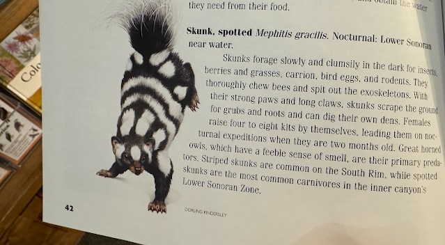
Of course, going to bed that early meant that I'd have to get up to pee. Sure enough, at 1 a.m. I had to pee. Shortly after returning to the tent, I heard a rustling around our packs. Tired, I wanted to ignore it, but I also didn't want my prized brownies to be liberated by some camp thief. I turned my headlamp on the commotion and came face to furry tail with the most common carnivore in the lower canyon. I didn't know this then, but I wasn't intimidated. I yelled at it, but, being such a fearsome carnivore, it wasn't easily deterred. I was going to have to do battle. I wasn't born to this greatness but rather had it thrust upon me. I picked up a small rock and hurled it, Nolan-Ryan-like, at the marauder. It turned fuzzy black and white tail and scampered off. It was a spotted skunk.
We were up at 6 a.m. After some coffee and food, we broke camp and were hiking by 7:15 a.m. We had 15 miles to cover and 4700 vertical feet. We took it slow with frequent, short breaks. Still two miles before we hit
Havasupai (Indian Garden), we ran into Steve. He came down to hike back up with us and to test his ankle.
He was using poles to protect his ankle, but a normal person would be sitting on the couch healing. He's a nut.
He'd end up with nearly the same mileage that we did.
At Havasupai, we joined the Bright Angel Trail and a lot more hikers. The Bright Angel, along with the South Kaibab are the two more popular trails that descend into the canyon. We still had 4.5 miles and 3000 feet to climb, but we just plugged along. It's never easy getting out of the Big Ditch. This was only Sheri's second time down into the Grand, but the rest of us had hiked out many times. We knew the drill. And it is always a great feeling to finally emerge onto flat ground. Despite this great feeling, the ten additional minutes it took us to hike to Steve's house seemed long. I was so ready to take off my shoes...
After a shower and a huge dinner of Mexican food in Tusayan, Derek and I decided that a marathon day on Zoroaster was best done before doing two biggish days in the canyon. We fell back to Plan B: moderate towers down a new trail for us with "only" 3700 feet of vertical gain.
Tuesday, March 25th: Escalante and Cardenas Buttes
This morning, we parted ways with Steve and his family and Homie, as he was heading south to join his family,
also on Spring Break. Sheri, Derek, and I headed for the Tanner Trail, 25 miles east. It was an easy drive down there,
and we packed up our minimal gear in the parking lot. Sheri was going to join us for as long as it was fun for her.
This turned out to be not very far, as the start of the trail, the top of the north-facing trail, was very icy. We had
spikes in the car, but thought we could get by. Derek and I could, just barely, but it was too much for Sheri. I offered
to go get her spikes, but she demurred. She originally wasn't going to go at all. She was tired and wanted to relax
and read her book. She had earned a rest and turned back for the rim.
Derek and I negotiated 400 vertical feet of icy trails before hitting dry terrain. Why so icy out here? This trailhead is 600 feet higher (7400 feet) than the Bright Angel Trailhead (6800 feet), and that made all the difference.
We'd met a hiker the day before who had done these buttes before and recommended starting with Escalante (the first one we came upon) and just running the ridge all the way to Cardenas. This was different from Steve's route and Homie's route, so we liked the idea of having a third track for our group. This turned out to be a great way to link these. We ended up topping six summits.
Escalante was mostly steep, loose hiking with some scrambling. This is all off-trail, of course. There are no trails to the summits of any of the temples. We topped an intermediate summit and continued upwards, weaving our way through huge blocks of sandstone. Derek led the way and atop a final scrambling section he said, "I found the step-across move". This temple is known for having an intimidating step/jump to get to the highest point. Indeed, it is an airy gap you must cross, but we are both near six feet tall, and the step was no big deal. I could easily span the gap, and I'm not flexible.
We took a short break on the summit to sign the register, eat, drink, and plan our strategy for the next summit. When it came time to reverse the step-across move, we both balked. It seemed much more daunting to get back. Part of this was the geometry. Instead of crossing a sloped wall where we use our momentum to quickly move away from the gap, going back, we faced a vertical wall with just the tiny ledge that we pushed off of to get to the top. Now, we couldn't use momentum, as we'd just hit the wall and bounce back into the gap, falling to our deaths. Or just get into the same stem but in the reverse direction. Your choice. We both moved a bit to the north and did a minor jump.
Next up was "Escaldenas" -- the love child of Escalante and Cardenas. Each summit required problem-solving to get through the vertical bands of Supai sandstone. We did the familiar weave back and forth between the vertical layers, searching for a weakness. This is normally the meat of temple climbing, but on this trip, it was the only time we did it, and it was minimal.
On to Cardenas. We dispatched it, but not without me making another slight mistake and, this time, scraping up my right wrist. I did a good enough job on it that I taped it up. We took another break on this summit, huddling in the shade of a summit boulder.
The last two nubbins along the ridge fell in short order but provided some picturesque scrambling. Afterwards, we descended to the Tanner Trail and followed it back to the rim. We ran into a few hikers on our way up, but this trail is relatively uncrowded. We took another long break in the shade before the final 2,000-foot climb. With 1000 feet to go, Derek told me that we had 30 minutes to be "on time" for our 6-hour estimate. I asked Derek, "Should we make it?" He responded affirmatively. That was all the motivation I needed, and we powered out of there in 24 minutes. We arrived back at the car, soaked but satisfied. Sheri was just leaving to meet us, so perfect timing.
After drinks, snacks, and stories, we headed to the Bright Angel Lodge. Sheri had booked us a room. We had a great
last night and an early-morning hike along the rim to watch the sunrise. The Grand Canyon never disappoints.
We'll be back!